IMAGES TAKEN NEAR TO
St. Peter Street, TIVERTON, EX16 6NR
Introduction
This page details the photographs taken nearby to St. Peter Street, EX16 6NR by members of the Geograph project.
The Geograph project started in 2005 with the aim of publishing, organising and preserving representative images for every square kilometre of Great Britain, Ireland and the Isle of Man.

There are currently over 7.5m images from over14,400 individuals and you can help contribute to the project by visiting https://www.geograph.org.uk
Image Map
Images are licensed for reuse under creativecommons.org/licenses/by-sa/2.0
Notes
- Clicking on the map will re-center to the selected point.
- The higher the marker number, the further away the image location is from the centre of the postcode.
Image Listing (2148 Images Found)
Images are licensed for reuse under creativecommons.org/licenses/by-sa/2.0
Image
Details
Distance
1

St Peter Street scaffolding, Tiverton
Viewed in July 2019.
Image: © Jaggery
Taken: 23 Jul 2019
0.01 miles
2
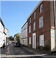
North along St Peter Street, Tiverton
Ahead for Newport Street.
Image: © Jaggery
Taken: 23 Jul 2019
0.01 miles
3
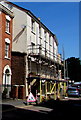
Scaffolding on the west side of St Peter Street, Tiverton
Viewed in July 2019.
Image: © Jaggery
Taken: 23 Jul 2019
0.01 miles
4

Former Wood shop, 33 St Peter Street, Tiverton
A SOLD board is on the wall on July 23rd 2019.
Image: © Jaggery
Taken: 23 Jul 2019
0.01 miles
5

Dental surgery at 37 St Peter Street, Tiverton
The name on the wall is {my} dentist. The unusual name format is squiggly brackets and all lowercase letters.
Image: © Jaggery
Taken: 23 Jul 2019
0.02 miles
6
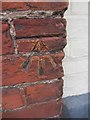
Ordnance Survey Cut Mark
This OS cut mark can be found on No50 St Peter's Street. It marks a point 73.870m above mean sea level.
Image: © Adrian Dust
Taken: 19 Feb 2014
0.02 miles
7

Directions signs alongside St Peter Street, Tiverton
Right for the market, a 180 capacity car park and the Grand Western Canal.
Left for Tiverton Castle and Knightshayes Court & Gardens.
Image: © Jaggery
Taken: 23 Jul 2019
0.02 miles
8

Tiverton: St Peter's Street from the churchyard gateway
The end of the street to its junction with Angel Hill is hidden by a bend in the road, but shown in Image
Image: © Martin Tester
Taken: 30 Sep 2019
0.02 miles
9
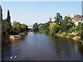
River Exe from Bridge Street
This view looks north from Bridge Street with the River Exe flowing alongside the St Peter's church.
Image: © Kieron McMahon
Taken: 9 Aug 2003
0.02 miles
10

Tiverton: Polish Centre, St Peter's Street
Image: © Christopher Hilton
Taken: 16 Aug 2010
0.02 miles