IMAGES TAKEN NEAR TO
Elmore Way, TIVERTON, EX16 6ED
Introduction
This page details the photographs taken nearby to Elmore Way, EX16 6ED by members of the Geograph project.
The Geograph project started in 2005 with the aim of publishing, organising and preserving representative images for every square kilometre of Great Britain, Ireland and the Isle of Man.

There are currently over 7.5m images from over14,400 individuals and you can help contribute to the project by visiting https://www.geograph.org.uk
Image Map
Images are licensed for reuse under creativecommons.org/licenses/by-sa/2.0
Notes
- Clicking on the map will re-center to the selected point.
- The higher the marker number, the further away the image location is from the centre of the postcode.
Image Listing (318 Images Found)
Images are licensed for reuse under creativecommons.org/licenses/by-sa/2.0
Image
Details
Distance
1

Tiverton : Houses on Siddals Gardens
Gardens and houses along the road at Siddals Gardens.
Image: © Lewis Clarke
Taken: 24 Jul 2012
0.08 miles
2

Tiverton : Watery Lane
Watery Lane in Tiverton beside Amory Park with Siddals Gardens on the left.
Image: © Lewis Clarke
Taken: 20 Dec 2010
0.08 miles
3
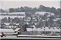
Tiverton : Snowy Tiverton Scene
From Amory Park looking towards Canal Hill and the snowy hillsides.
Image: © Lewis Clarke
Taken: 20 Dec 2010
0.09 miles
4
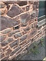
Cowleymoor Road, Tiverton
69.89m above Ordnance Datum Newlyn (Tide Gauge Bolt Newlyn Pier - the authoritative datum for the UK). It was last verified in 1969. Grid ref: SS 9608 1319. Description: BLDG SE SIDE COWLEY MOOR RD NW FACE 3.7M W ANG.
Close up Image
Image: © Meg Hepworth
Taken: 10 Sep 2020
0.10 miles
5
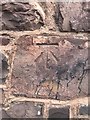
Cowleymoor Road, Tiverton
This is a cut benchmark, 0.7m above the ground and 69.89m above Ordnance Datum Newlyn (Tide Gauge Bolt Newlyn Pier - the authoritative datum for the UK). It was last verified in 1969. Grid ref: SS 9608 1319.
Wider angle: Image
Image: © Meg Hepworth
Taken: 10 Sep 2020
0.10 miles
6
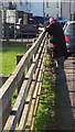
Tiverton : Amory Park
Amory Park in Tiverton and a woman at the fence.
Image: © Lewis Clarke
Taken: 18 Jan 2017
0.10 miles
7
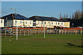
Tiverton : Amory Park
A goal post and park with houses behind them.
Image: © Lewis Clarke
Taken: 18 Jan 2017
0.10 miles
8

Tiverton : Threwstone Close
Gardens and bungalows along Threwstone Close in Tiverton.
Image: © Lewis Clarke
Taken: 24 Jul 2012
0.10 miles
10

Tiverton : Salvation Army Hall
The logo on the front of the Salvation Army Hall on Chapel Street in Tiverton.
Image: © Lewis Clarke
Taken: 13 Nov 2021
0.11 miles