IMAGES TAKEN NEAR TO
Hemyock, CULLOMPTON, EX15 3UF
Introduction
This page details the photographs taken nearby to EX15 3UF by members of the Geograph project.
The Geograph project started in 2005 with the aim of publishing, organising and preserving representative images for every square kilometre of Great Britain, Ireland and the Isle of Man.

There are currently over 7.5m images from over14,400 individuals and you can help contribute to the project by visiting https://www.geograph.org.uk
Image Map
Images are licensed for reuse under creativecommons.org/licenses/by-sa/2.0
Notes
- Clicking on the map will re-center to the selected point.
- The higher the marker number, the further away the image location is from the centre of the postcode.
Image Listing (8 Images Found)
Images are licensed for reuse under creativecommons.org/licenses/by-sa/2.0
Image
Details
Distance
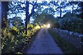
1
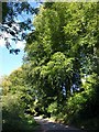
Lane up Combe Hill
The lane from Culm Pyne Barton climbs beneath trees past the driveway to Grey Walls.
Image: © Derek Harper
Taken: 4 Oct 2010
0.04 miles
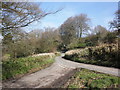
3
Mid Devon : Country Road
A countryside road heading down towards Hemyock in Mid Devon.
Image: © Lewis Clarke
Taken: 28 Jun 2012
0.08 miles
4
Mid Devon : Country Road
A car with its headlights on approaching from around the corner at 10:07pm.
Image: © Lewis Clarke
Taken: 28 Jun 2012
0.08 miles

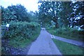
6
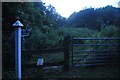
Mid Devon : Public Footpath
A public footpath heads off the road and up towards Somerset.
Image: © Lewis Clarke
Taken: 28 Jun 2012
0.14 miles
7

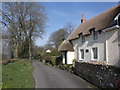
Mid Devon : Country Road & Pen Cross House
Pen Cross House in Mid Devon just outside of Hemyock.
Image: © Lewis Clarke
Taken: 28 Jun 2012
0.21 miles