IMAGES TAKEN NEAR TO
Plymtree, CULLOMPTON, EX15 2LR
Introduction
This page details the photographs taken nearby to EX15 2LR by members of the Geograph project.
The Geograph project started in 2005 with the aim of publishing, organising and preserving representative images for every square kilometre of Great Britain, Ireland and the Isle of Man.

There are currently over 7.5m images from over14,400 individuals and you can help contribute to the project by visiting https://www.geograph.org.uk
Image Map
Images are licensed for reuse under creativecommons.org/licenses/by-sa/2.0
Notes
- Clicking on the map will re-center to the selected point.
- The higher the marker number, the further away the image location is from the centre of the postcode.
Image Listing (7 Images Found)
Images are licensed for reuse under creativecommons.org/licenses/by-sa/2.0
Image
Details
Distance
1
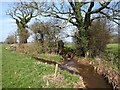
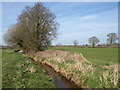
Stream junction near Old Bridge
The River Weaver (left, flowing towards the camera) is joined by a tributary from the east, beneath ivy-cpvered oaks.
Image: © Derek Harper
Taken: 19 Mar 2011
0.05 miles
2
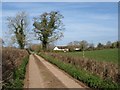
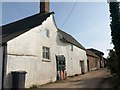
Approaching Old Bridge
From the farm road for Sanguishayes, on Plymtree Footpath 7, as it passes ivy-covered trees. The listed Old Bridge Farmhouse, "possibly early C16" http://www.britishlistedbuildings.co.uk/en-95266-old-bridge-farmhouse-cullompton , is mostly in Image
Image: © Derek Harper
Taken: 19 Mar 2011
0.07 miles
3
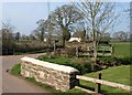
Old Bridge
The bridge in the foreground is across a tributary of the River Weaver, which crosses the road just by the footpath sign (for Cullompton Footpath 22); the metal fence parapet can be seen, and water level gauges indicate that the stream often flows over the road. In the background is the listed Old Bridge Cottage http://www.britishlistedbuildings.co.uk/en-95265-old-bridge-cottage-cullompton .
Image: © Derek Harper
Taken: 19 Mar 2011
0.08 miles
4
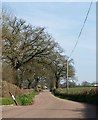
Old Bridge Road
The tree-lined lane leads away from Old Bridge towards Norman's Green; the parish boundary between Plymtree and Cullompton follows it.
Image: © Derek Harper
Taken: 19 Mar 2011
0.10 miles
5
Sanguishayes Farm
Variously spelt Sanquishayes (on maps) and Sanguishes (on the listed building description http://www.britishlistedbuildings.co.uk/en-86891-sanguishes-farmhouse-plymtree ), the farm is C16 in origin. Plymtree Footpath 7 runs alongside.
Image: © Derek Harper
Taken: 19 Mar 2011
0.11 miles
6
River Weaver
Looking upstream as the river teeters along the easting gridline; I think I am a metre or so the other side from it at the moment.
Image: © Derek Harper
Taken: 19 Mar 2011
0.14 miles
7
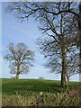
Oaks near Sanguishayes Farm
Across a field boundary from Plymtree Footpath 7. There was a pond here but it seems to have gone.
Image: © Derek Harper
Taken: 19 Mar 2011
0.23 miles