IMAGES TAKEN NEAR TO
Oak Close, CULLOMPTON, EX15 2EF
Introduction
This page details the photographs taken nearby to Oak Close, EX15 2EF by members of the Geograph project.
The Geograph project started in 2005 with the aim of publishing, organising and preserving representative images for every square kilometre of Great Britain, Ireland and the Isle of Man.

There are currently over 7.5m images from over14,400 individuals and you can help contribute to the project by visiting https://www.geograph.org.uk
Image Map
Images are licensed for reuse under creativecommons.org/licenses/by-sa/2.0
Notes
- Clicking on the map will re-center to the selected point.
- The higher the marker number, the further away the image location is from the centre of the postcode.
Image Listing (22 Images Found)
Images are licensed for reuse under creativecommons.org/licenses/by-sa/2.0
Image
Details
Distance
2
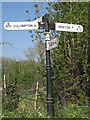
Direction Sign ? Signpost on the A373 at Dulford
Located on the north side of Four Lanes junction on the A373 near Oak Close, Dulford, in Broadhembury parish. 4 arms, 1 worboys, and no finial.
Milestone Society National ID: DV_ST0705
Image: © T Jenkinson
Taken: 6 May 2008
0.03 miles
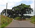
4
At Four Lanes junction heading east on A373 near Dulford
Image: © Rob Purvis
Taken: 2 Feb 2023
0.04 miles
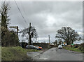
5
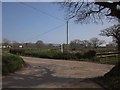
Junction near Dulford
The lane from St Andrew's Wood reaches a T-junction with the road from Dulford (left) down the west side of the Tale valley.
Image: © Derek Harper
Taken: 24 Mar 2012
0.11 miles
6
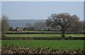
Fields near Dulford
Looking across field boundaries from the road shown in Image The second field boundary marks the course of the A373. The house on the left has gone for solar panels.
Image: © Derek Harper
Taken: 24 Mar 2012
0.12 miles
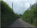
7
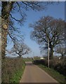
Oaks by the road, near Dulford
The signpost is at the junction shown in Image
Image: © Derek Harper
Taken: 24 Mar 2012
0.12 miles
9
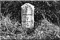
Old Milestone by the A373, Dulford, Broadhembury Parish
Honiton gabled stone by the A373, in parish of Broadhembury (East Devon District), Dulford, by the East side of road.
Inscription reads:- : HONITON / 7 / CULLOMPTON / 4 :
Carved bench mark on lower face.
Lost since 1970.
Milestone Society National ID: DV_CMHN04
Image: © Milestone Society
Taken: Unknown
0.13 miles
10
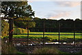
East Devon : : Grassy Field & Gate
A grassy field and gate in the East Devon countryside.
Image: © Lewis Clarke
Taken: 14 Aug 2014
0.13 miles