IMAGES TAKEN NEAR TO
Exmoor Way, CULLOMPTON, EX15 1TU
Introduction
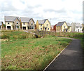
This page details the photographs taken nearby to Exmoor Way, EX15 1TU by members of the Geograph project.
The Geograph project started in 2005 with the aim of publishing, organising and preserving representative images for every square kilometre of Great Britain, Ireland and the Isle of Man.

There are currently over 7.5m images from over14,400 individuals and you can help contribute to the project by visiting https://www.geograph.org.uk
Image Map
Images are licensed for reuse under creativecommons.org/licenses/by-sa/2.0
Notes
- Clicking on the map will re-center to the selected point.
- The higher the marker number, the further away the image location is from the centre of the postcode.
Image Listing (77 Images Found)
Images are licensed for reuse under creativecommons.org/licenses/by-sa/2.0
Image
Details
Distance
1

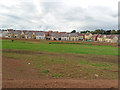
Green-belt housing invasion, Cullompton
Image: © Roger Cornfoot
Taken: 28 Sep 2016
0.03 miles
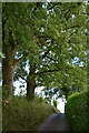
2

Cullompton : Knowle Lane
Looking along Knowle Lane.
Image: © Lewis Clarke
Taken: 1 Jul 2017
0.05 miles
3
Cullompton: towards Greystone Walk
Seen from Knowle Lane, now linked to the new housing development by a footpath
Image: © Martin Bodman
Taken: 31 Jul 2019
0.05 miles
4
Cullompton : Knowle Lane
Looking along Knowle Lane in Mid Devon.
Image: © Lewis Clarke
Taken: 1 Jul 2017
0.06 miles
5
Cullompton : Dartmoor Way
At the end of the occupied row of homes with development still taking place.
Image: © Lewis Clarke
Taken: 11 Jan 2018
0.08 miles
6
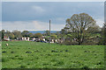
Cullompton: towards St Andrew's Hill
Farmland and housing at the north western edge of Cullompton town. The Blackdown ridge is visible, in the distance, on the skyline
Image: © Martin Bodman
Taken: 16 Apr 2011
0.09 miles
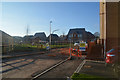
7
Cullompton: Saxon Fields Development
Development by Barratt Homes. New housing in Dartmoor Way, seen from Dorset Down Crescent
Image: © Martin Bodman
Taken: 8 Aug 2017
0.09 miles
8
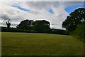
Cullompton : Grassy Field
A grassy field seen off of Knowle Lane.
Image: © Lewis Clarke
Taken: 1 Jul 2017
0.09 miles
9

Cullompton: Dartmoor Way
Seen from a link path from Exmoor Way. Part of the new housing development at the edge of the town. A stream runs through the flood plain
Image: © Martin Bodman
Taken: 13 Mar 2018
0.09 miles
10
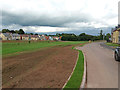
Cullompton: on Dorset Down Crescent
With the Saxon Fields development on the left
Image: © Martin Bodman
Taken: 8 Aug 2017
0.09 miles