IMAGES TAKEN NEAR TO
Spindlebury, CULLOMPTON, EX15 1SY
Introduction
This page details the photographs taken nearby to Spindlebury, EX15 1SY by members of the Geograph project.
The Geograph project started in 2005 with the aim of publishing, organising and preserving representative images for every square kilometre of Great Britain, Ireland and the Isle of Man.

There are currently over 7.5m images from over14,400 individuals and you can help contribute to the project by visiting https://www.geograph.org.uk
Image Map
Images are licensed for reuse under creativecommons.org/licenses/by-sa/2.0
Notes
- Clicking on the map will re-center to the selected point.
- The higher the marker number, the further away the image location is from the centre of the postcode.
Image Listing (56 Images Found)
Images are licensed for reuse under creativecommons.org/licenses/by-sa/2.0
Image
Details
Distance
1
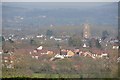
Mid Devon : Cullompton Scenery
Looking towards the town of Cullompton in Mid Devon.
Image: © Lewis Clarke
Taken: 29 Mar 2014
0.02 miles
2
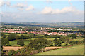
Mid Devon : Cullompton Scenery
Looking across the countryside towards the Mid Devon town of Cullompton.
Image: © Lewis Clarke
Taken: 29 Mar 2014
0.02 miles
3
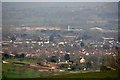
Cullompton: the town from the south west
Seen from a field near Russell Lane – at ST001062
Image: © Martin Bodman
Taken: 20 Sep 2005
0.02 miles
4
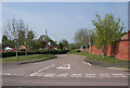
Cullompton: Colebrooke Lane
Junction with Swallow Way on the edge of town. An urban section of the lane continues behind the camera to junction with Exeter Road
Image: © Martin Bodman
Taken: 20 Apr 2011
0.05 miles
5

Swallow Way, Cullompton
Another view of the residential area shown in Image On the right is Clover Drive.
Image: © Derek Harper
Taken: 28 Nov 2008
0.05 miles
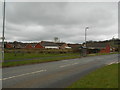
6

Cullompton: Swallow Way
Junction of Swallow Way and Colebrooke Lane. A relatively new residential area of Cullompton; Colebrooke Chase in estate agents’ notices, known by others as ‘The Birds’, with street names such as ‘Larks Rise’, ‘Kingfisher Gardens’ and ‘Robin Close’
Image: © Martin Bodman
Taken: Unknown
0.06 miles
7
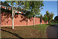
Cullompton: wall by Swallow Way
In Colebrooke Lane, just short of its junction with Swallow Way
Image: © Martin Bodman
Taken: 18 Oct 2011
0.06 miles
8
A bus shelter and a bench
Swallow Lane, Cullompton.
Image: © Anthony Vosper
Taken: 7 Apr 2018
0.07 miles
9
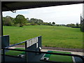
Cullompton : Padbrook Park Golf Course
A driving range on Padbrook Park golf complex in Cullompton.
Image: © Lewis Clarke
Taken: 18 May 2010
0.08 miles
10
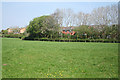
Cullompton: edge of town
Housing estates border farmland on the western edge of the town
Image: © Martin Bodman
Taken: 20 Apr 2011
0.08 miles