IMAGES TAKEN NEAR TO
Holly Way, CULLOMPTON, EX15 1SX
Introduction
This page details the photographs taken nearby to Holly Way, EX15 1SX by members of the Geograph project.
The Geograph project started in 2005 with the aim of publishing, organising and preserving representative images for every square kilometre of Great Britain, Ireland and the Isle of Man.

There are currently over 7.5m images from over14,400 individuals and you can help contribute to the project by visiting https://www.geograph.org.uk
Image Map
Images are licensed for reuse under creativecommons.org/licenses/by-sa/2.0
Notes
- Clicking on the map will re-center to the selected point.
- The higher the marker number, the further away the image location is from the centre of the postcode.
Image Listing (67 Images Found)
Images are licensed for reuse under creativecommons.org/licenses/by-sa/2.0
Image
Details
Distance
1
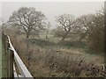
Trees by the Mill Race
Thick frost on the roadside fence beside Millennium Way, and the patch of meadow between it and the mill race along the Culm valley, lined with trees.
Image: © Derek Harper
Taken: 6 Dec 2010
0.09 miles
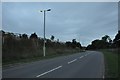
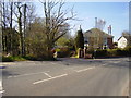
2
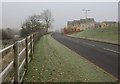
Millennium Way, Cullompton
The road skirts new housing north of the town; this stepped terrace of houses is on Fairfax Drive. The fence on the left also appears in Image A frosty, rather foggy, morning.
Image: © Derek Harper
Taken: 6 Dec 2010
0.10 miles
3
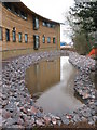
The Cullompton Health Centre Pond
Not very visually appealing in this shot as we were still under construction. The site is built at the bottom of what was sloping agricultural land which in heavy rainfall conditions would contribute copious amounts of run off into the town's drainage system. This is not ideal as the site is at the top end of the drain system. The hole just visible in the centre of shot leads down into a holding tank which delays the release of excess water into the drains. More drainage tricks will be needed as we cover over the land behind this site with proposed housing.
Image: © brian lee
Taken: 25 Jan 2008
0.10 miles
4
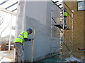
Finishing up
Finally applying the 1.5mm thick Acrylic finish coat with hawk and trowel. The solid block wall (by mistake) is covered in an anticrack fibreglass mesh overlapped on all joints to aid strength and stop cracking. There is no cement in these products, relying on air movement and evaporation to dry, a challenge in English weather conditions. Fibreglass corner beads are applied with a straight edge and access to the high areas was conducted off a tower scaffold which is not every workers ideal. Being under Health and Safety guidelines operatives on site where required to wear hard hats and steel toe cap boots, the high visibility vest a requirement on sites with motor traffic. The final coat applied at 1.5mm is trowelled to achieve flatness and texture, this side being in the shade took three days to dry. When dry it is colour fast waterproof and low maintenance for up to 20 years making it ideal on this project.
Image: © brian lee
Taken: 9 Feb 2008
0.11 miles
5
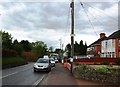
Cullompton : Millennium Way
Looking along Millennium Way which heads out of Cullompton.
Image: © Lewis Clarke
Taken: 8 Aug 2013
0.11 miles
7
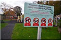
Cullompton : Head Weir Road Play Area
A sign with all the information about the park.
Image: © Lewis Clarke
Taken: 11 Nov 2021
0.12 miles
8
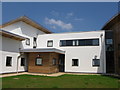
The South End
A challenging build of Steel frame infilled with concrete block. A well insulated roof clad mainly in Zinc. All white areas are 100mm thick polystyrene slabs bolted to the blockwork, plastered over with a German Acrylic render system. The rest of the façade is of Cedarwood, a low maintenance sustainable pine from the Mediterranean, considered to age well and have a nice grain and is of a reasonable quality to work with. Cedarwood also has excellent weather repellent properties being oily and repellent to moths. High grade K-class windows finish the weather seal for this 2008 public Health Centre.
Image: © brian lee
Taken: 7 May 2008
0.12 miles
9
Bridleway off Welland Road
Follow this bridleway up hill to the Paulsland Farm Trig Point for some worthwhile views.
Image: © Anthony Vosper
Taken: 23 Apr 2010
0.12 miles
10

Cullompton : Head Weir Road Play Area
A play area at Head Weird Road.
Image: © Lewis Clarke
Taken: 11 Nov 2021
0.12 miles