IMAGES TAKEN NEAR TO
St. Andrews Estate, CULLOMPTON, EX15 1HZ
Introduction
This page details the photographs taken nearby to St. Andrews Estate, EX15 1HZ by members of the Geograph project.
The Geograph project started in 2005 with the aim of publishing, organising and preserving representative images for every square kilometre of Great Britain, Ireland and the Isle of Man.

There are currently over 7.5m images from over14,400 individuals and you can help contribute to the project by visiting https://www.geograph.org.uk
Image Map
Images are licensed for reuse under creativecommons.org/licenses/by-sa/2.0
Notes
- Clicking on the map will re-center to the selected point.
- The higher the marker number, the further away the image location is from the centre of the postcode.
Image Listing (355 Images Found)
Images are licensed for reuse under creativecommons.org/licenses/by-sa/2.0
Image
Details
Distance
1

Cullompton : St Andrew's Road
Police and forensic teams attend the scene where a man has died.
Image: © Lewis Clarke
Taken: 6 Jun 2020
0.04 miles
2
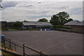
Cullompton : St Andrew's Primary School
St Andrew's in Cullompton, looking out to the playground.
Image: © Lewis Clarke
Taken: 4 Jun 2015
0.04 miles
3

Cullompton : St Andrew's Road
Police have closed the road due to the death of a man.
Image: © Lewis Clarke
Taken: 6 Jun 2020
0.05 miles
4

Cullompton : St Andrew's Primary School
St Andrews Primary School in Cullompton.
Image: © Lewis Clarke
Taken: 5 Oct 2016
0.06 miles
5

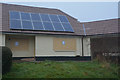
Cullompton : St Andrew's Estate Bungalow
A property in Cullompton has been closed after a loft fire was sparked by the tenant growing cannabis - and investigators say the blaze could have killed a family.
Mid Devon District Council has obtained a Closure Order following the fire on St Andrews Estate.
Read more at http://www.exeterexpressandecho.co.uk/council-take-action-after-loft-fire-reveals-large-scale-cannabis-cultivation-in-cullompton/story-30082269-detail/story.html#1R71ltezzPKx80qM.99
Image: © Lewis Clarke
Taken: 24 Jan 2017
0.06 miles
6

Cullompton : St Andrew's Estate Bungalow
A property in Cullompton has been closed after a loft fire was sparked by the tenant growing cannabis - and investigators say the blaze could have killed a family.
Mid Devon District Council has obtained a Closure Order following the fire on St Andrews Estate.
Read more at http://www.exeterexpressandecho.co.uk/council-take-action-after-loft-fire-reveals-large-scale-cannabis-cultivation-in-cullompton/story-30082269-detail/story.html#1R71ltezzPKx80qM.99
Image: © Lewis Clarke
Taken: 24 Jan 2017
0.06 miles
7
Cullompton : St Andrew's Estate Bungalow
A property in Cullompton has been closed after a loft fire was sparked by the tenant growing cannabis - and investigators say the blaze could have killed a family.
Mid Devon District Council has obtained a Closure Order following the fire on St Andrews Estate.
Read more at http://www.exeterexpressandecho.co.uk/council-take-action-after-loft-fire-reveals-large-scale-cannabis-cultivation-in-cullompton/story-30082269-detail/story.html#1R71ltezzPKx80qM.99
Image: © Lewis Clarke
Taken: 24 Jan 2017
0.06 miles
9
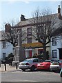
Cullompton: High Street
View towards war memorial, with China Orchid restaurant partly obscured by Christmas tree
Image: © Martin Bodman
Taken: 3 Jan 2018
0.09 miles
10

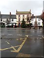
Cullompton : High Street
Looking along the pavement of the High Street.
Image: © Lewis Clarke
Taken: 14 Nov 2021
0.09 miles