IMAGES TAKEN NEAR TO
Station Road, CULLOMPTON, EX15 1AH
Introduction
This page details the photographs taken nearby to Station Road, EX15 1AH by members of the Geograph project.
The Geograph project started in 2005 with the aim of publishing, organising and preserving representative images for every square kilometre of Great Britain, Ireland and the Isle of Man.

There are currently over 7.5m images from over14,400 individuals and you can help contribute to the project by visiting https://www.geograph.org.uk
Image Map
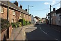
Images are licensed for reuse under creativecommons.org/licenses/by-sa/2.0
Notes
- Clicking on the map will re-center to the selected point.
- The higher the marker number, the further away the image location is from the centre of the postcode.
Image Listing (397 Images Found)
Images are licensed for reuse under creativecommons.org/licenses/by-sa/2.0
Image
Details
Distance
1

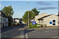
Cullompton : Station Road
Traffic builds on Station Road.
Image: © Lewis Clarke
Taken: 26 Jun 2021
0.01 miles
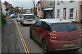
2
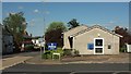
Cullompton Police Station
Built in 1973, but significantly refurbished in 2011, this police station on Station Road provides a policing hub for the Culm Valley.
Image: © Stephen McKay
Taken: 10 Aug 2017
0.01 miles
3
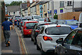
Police station, Cullompton
The replacement for Image], and located less centrally on Station Road (left) at the junction with Forge Way.
Image: © Derek Harper
Taken: 15 May 2016
0.02 miles
4
Cullompton : Station Road
Traffic builds on Station Road.
Image: © Lewis Clarke
Taken: 26 Jun 2021
0.03 miles
5
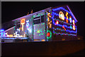
Cullompton : House on Forge Road
A house decorated for the festive season on Forge Road.
Image: © Lewis Clarke
Taken: 16 Dec 2015
0.03 miles
6
Trott's Almshouses, Cullompton
The listed almshouses are in the sun on the left; they were originally built in 1523 but have been heavily restored https://www.historicengland.org.uk/listing/the-list/list-entry/1306826 . The traffic lights are at the junction with Station Road on the left; both that and the road in the foreground, Higher Street, together with the main road through the town centre ahead, are numbered the B3181, though when Station Road reaches the M5 junction, the A373 takes over.
Image: © Derek Harper
Taken: 15 May 2016
0.04 miles
7
Cullompton : Higher Street B3181
Looking along the B3181.
Image: © Lewis Clarke
Taken: 20 Nov 2021
0.04 miles
8

Higher Street, Cullompton
The B3181 leaving the town centre; a short way ahead it becomes Willand Road. On the extreme right is part of the terrace of six Trott's Almshouses, originally built in 1523 but heavily restored https://www.historicengland.org.uk/listing/the-list/list-entry/1306826 .
Image: © Derek Harper
Taken: 15 May 2016
0.04 miles
9
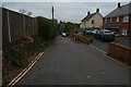
Cullompton : Higher Mill Lane
Looking along Higher Mill Lane.
Image: © Lewis Clarke
Taken: 20 Nov 2021
0.05 miles
10
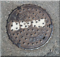
Cullompton: man-hole cover
Cast by Garton & King Ltd, ironfounders of Exeter. At the top of Higher Mill Lane, it incorporates a road marking
Image: © Martin Bodman
Taken: 6 May 2018
0.05 miles