IMAGES TAKEN NEAR TO
Upottery, HONITON, EX14 9PZ
Introduction
This page details the photographs taken nearby to EX14 9PZ by members of the Geograph project.
The Geograph project started in 2005 with the aim of publishing, organising and preserving representative images for every square kilometre of Great Britain, Ireland and the Isle of Man.

There are currently over 7.5m images from over14,400 individuals and you can help contribute to the project by visiting https://www.geograph.org.uk
Image Map
Images are licensed for reuse under creativecommons.org/licenses/by-sa/2.0
Notes
- Clicking on the map will re-center to the selected point.
- The higher the marker number, the further away the image location is from the centre of the postcode.
Image Listing (7 Images Found)
Images are licensed for reuse under creativecommons.org/licenses/by-sa/2.0
Image
Details
Distance
1
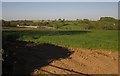
Hugginshayes Farm
The farm buildings glimpsed from a gateway close to where Image was taken. Beyond is the Umborne Brook valley.
Image: © Derek Harper
Taken: 22 May 2012
0.12 miles
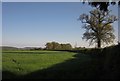
2
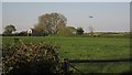
Upottery : Grassy Field
A grassy field and the beacon in the distance.
Image: © Lewis Clarke
Taken: 13 Nov 2020
0.21 miles
3

Upottery : Track
A track to Hugginshayes.
Image: © Lewis Clarke
Taken: 13 Nov 2020
0.23 miles
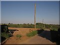
4
Field by Viney Lane
The lane is behind the hedge on the right. Taken from the same spot as Image
Image: © Derek Harper
Taken: 22 May 2012
0.23 miles
5
Lane to Hugginshayes Farm
The farm road seen from its junction with Viney Lane. The farm is out of sight down the slopes of the Umborne Brook valley; but see Image
Image: © Derek Harper
Taken: 22 May 2012
0.23 miles
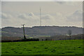
6
Barn and aircraft, Rawridge Hill
A view from the same spot as Image, with a low-flying aircraft and a barn and trees in the corner of a field by Viney Lane.
Image: © Derek Harper
Taken: 22 May 2012
0.24 miles
7
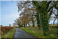
Upottery : Viney Lane
Looking along Viney Lane.
Image: © Lewis Clarke
Taken: 13 Nov 2020
0.24 miles