IMAGES TAKEN NEAR TO
Yarcombe, HONITON, EX14 9LX
Introduction
This page details the photographs taken nearby to EX14 9LX by members of the Geograph project.
The Geograph project started in 2005 with the aim of publishing, organising and preserving representative images for every square kilometre of Great Britain, Ireland and the Isle of Man.

There are currently over 7.5m images from over14,400 individuals and you can help contribute to the project by visiting https://www.geograph.org.uk
Image Map
Images are licensed for reuse under creativecommons.org/licenses/by-sa/2.0
Notes
- Clicking on the map will re-center to the selected point.
- The higher the marker number, the further away the image location is from the centre of the postcode.
Image Listing (4 Images Found)
Images are licensed for reuse under creativecommons.org/licenses/by-sa/2.0
Image
Details
Distance
1
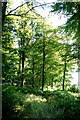
Peacross Covert
This small copse of mixed woodland is just off the minor road from Yarcombe to Stopgate Cross on the A303.
Image: © Nigel Mykura
Taken: 7 Aug 2015
0.13 miles
2
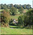
Whitehorn's Farm
A glimpse through field boundaries of a farm in a fold of the Yarty valley, north of Yarcombe, with a barn beyond Yarcombe Bridleway 31 (from which this was taken). Above is Peacross Covert.
Image: © Derek Harper
Taken: 21 Sep 2006
0.13 miles
3
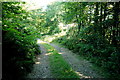
Track near Peacross Farm
This track runs through a small stretch of woods to give access to the fields just beyond.
Image: © Nigel Mykura
Taken: 7 Aug 2015
0.13 miles
4
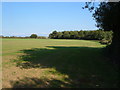
Field on Blackdown Hills
This looks like an early sowing of winter wheat on the plateau top above the Yarty valley near Yarcombe. Taken from Yarcombe Footpath 27. The building in the distance belongs to Sunnyfield.
Image: © Derek Harper
Taken: 21 Sep 2006
0.22 miles