IMAGES TAKEN NEAR TO
Yarcombe, HONITON, EX14 9LT
Introduction
This page details the photographs taken nearby to EX14 9LT by members of the Geograph project.
The Geograph project started in 2005 with the aim of publishing, organising and preserving representative images for every square kilometre of Great Britain, Ireland and the Isle of Man.

There are currently over 7.5m images from over14,400 individuals and you can help contribute to the project by visiting https://www.geograph.org.uk
Image Map
Images are licensed for reuse under creativecommons.org/licenses/by-sa/2.0
Notes
- Clicking on the map will re-center to the selected point.
- The higher the marker number, the further away the image location is from the centre of the postcode.
Image Listing (8 Images Found)
Images are licensed for reuse under creativecommons.org/licenses/by-sa/2.0
Image
Details
Distance
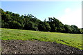
1
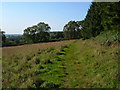
Yarcombe Footpath 26
The path skirts a wood on Beacon Hill, high on the slopes of the Yarty valley.
Image: © Derek Harper
Taken: 21 Sep 2006
0.02 miles
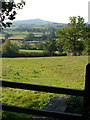
2
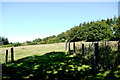
Field on Beacon Hill
This pasture field which lies to the east and north of the cottage (whose roof top is just visible) is just north of the A30 near Moorhayne.
Image: © Nigel Mykura
Taken: 7 Aug 2015
0.03 miles
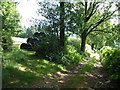
4
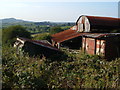
Old iron at Yarcombe
Poetic decay in these corrugated iron outbuildings near Stoneshells Cottage, beside the A30 above Yarcombe.
Image: © Derek Harper
Taken: 21 Sep 2006
0.15 miles
5
Field on Beacon Hill
As might be expected this steeply sloping field on the northern side of the minor road to Beacon, is only used for stock pasture.
Image: © Nigel Mykura
Taken: 7 Aug 2015
0.15 miles
6
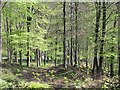
The A30 descends to Yarcombe
The A30 leaves the North Devon Plateau, descending through beech woods. There was some forestry work going on below, but obscured by the spring foliage.
Image: © Richard Webb
Taken: 20 Apr 2011
0.19 miles
7
Footpath near Yarcombe
Yarcombe Footpath 19 crosses a stile as it descends a slope in the Yarty valley. The faint outline of the old track it follows, curving to the left across the field, may just been made out. In the background is Beacon Hill near Heathstock.
Image: © Derek Harper
Taken: 21 Sep 2006
0.23 miles
8
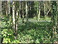
Red Scrip
Woodland on the steep edge of the East Devon Plateau. This is an uphill view from the A30 during the lovely descent to Yarcombe.
Image: © Richard Webb
Taken: 20 Apr 2011
0.24 miles