IMAGES TAKEN NEAR TO
Stockland, HONITON, EX14 9BS
Introduction
This page details the photographs taken nearby to EX14 9BS by members of the Geograph project.
The Geograph project started in 2005 with the aim of publishing, organising and preserving representative images for every square kilometre of Great Britain, Ireland and the Isle of Man.

There are currently over 7.5m images from over14,400 individuals and you can help contribute to the project by visiting https://www.geograph.org.uk
Image Map
Images are licensed for reuse under creativecommons.org/licenses/by-sa/2.0
Notes
- Clicking on the map will re-center to the selected point.
- The higher the marker number, the further away the image location is from the centre of the postcode.
Image Listing (32 Images Found)
Images are licensed for reuse under creativecommons.org/licenses/by-sa/2.0
Image
Details
Distance
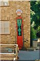
1
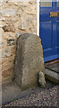
Old Bridge Marker, Stockland
Bridge Marker by the UC road, in parish of Stockland (East Devon District), opposite Kings Arms Inn, in village, 80m East of County Bridge, against wall of house.
surveyed
Milestone Society National ID: DV_SLHN01abr
Image: © Alan Rosevear
Taken: 2 Mar 2011
0.01 miles
2
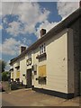
The King?s Arms, Stockland
There are more images of this pub, which dates from the C16 http://list.english-heritage.org.uk/resultsingle.aspx?uid=1333606&searchtype=mapsearch , at http://www.geograph.org.uk/search.php?i=41919190 . I was rather hoping for some sort of refreshment after a long and circuitous walk from Honiton, but the pub was closed and boarded up. This seems to be a repeat of 2011 http://www.midweekherald.co.uk/news/campaign_launched_to_save_stockland_pub_1_919672 .
Image: © Derek Harper
Taken: 25 May 2013
0.01 miles
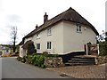
4
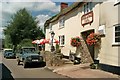
Stockland: The King?s Arms
The inn had its own entry in the Good Pub Guide 2005 and dates from the 16th century. It has a restaurant. Looking east
Image: © Martin Bodman
Taken: 27 Aug 2006
0.02 miles
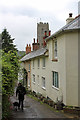
5
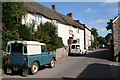
Stockland: by The King?s Arms
Looking west-north-west along the street leading towards Cotleigh and Honiton. The King's Arms is on the right past the for sale sign
Image: © Martin Bodman
Taken: 27 Aug 2006
0.02 miles
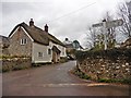
7

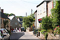
Junction in Stockland
At the heart of the village. Ahead is Yarcombe Road. Behind the camera is Churchway. On the left is Kite's Cottage, a "Circa 1500 hall house" http://list.english-heritage.org.uk/resultsingle.aspx?uid=1171310&searchtype=mapsearch . Opposite, behind the sign, King's Thatch, formerly a row of cottages http://list.english-heritage.org.uk/resultsingle.aspx?uid=1171319&searchtype=mapsearch .
Image: © Derek Harper
Taken: 25 May 2013
0.03 miles