IMAGES TAKEN NEAR TO
Yarcombe, HONITON, EX14 9AF
Introduction
This page details the photographs taken nearby to EX14 9AF by members of the Geograph project.
The Geograph project started in 2005 with the aim of publishing, organising and preserving representative images for every square kilometre of Great Britain, Ireland and the Isle of Man.

There are currently over 7.5m images from over14,400 individuals and you can help contribute to the project by visiting https://www.geograph.org.uk
Image Map
Images are licensed for reuse under creativecommons.org/licenses/by-sa/2.0
Notes
- Clicking on the map will re-center to the selected point.
- The higher the marker number, the further away the image location is from the centre of the postcode.
Image Listing (6 Images Found)
Images are licensed for reuse under creativecommons.org/licenses/by-sa/2.0
Image
Details
Distance
1
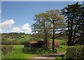
Barns, Sheafhayne Manor Farm
From the lane from Birch Cross, dropping towards the Yarty.
Image: © Derek Harper
Taken: 16 May 2013
0.05 miles
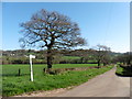

4
Road closed, Sheafhayne Cross
This is the road to the right in Image; normally it leads across the Yarty to Howley, but today you have to make a long diversion via Marsh. Never mind, it's nice countryside and a lovely spring day.
Image: © Derek Harper
Taken: 16 May 2013
0.09 miles
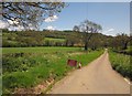
5
Yarcombe: bridge over the Yarty
The river is crossed on the skew and the bridge appears to be of recent construction. The road from Howley leads to Sheafhayne Cross. Looking west
Image: © Martin Bodman
Taken: 27 Aug 2006
0.20 miles
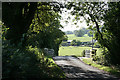
6
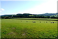
Fields near Birch Oak Farm
The fields are mainly pasture and stocked with sheep. The prominent wooded knoll in the distance is Knapp Copse in ST2610
Image: © Nigel Mykura
Taken: 7 Aug 2015
0.25 miles