IMAGES TAKEN NEAR TO
Yarcombe, HONITON, EX14 9AD
Introduction
This page details the photographs taken nearby to EX14 9AD by members of the Geograph project.
The Geograph project started in 2005 with the aim of publishing, organising and preserving representative images for every square kilometre of Great Britain, Ireland and the Isle of Man.

There are currently over 7.5m images from over14,400 individuals and you can help contribute to the project by visiting https://www.geograph.org.uk
Image Map
Images are licensed for reuse under creativecommons.org/licenses/by-sa/2.0
Notes
- Clicking on the map will re-center to the selected point.
- The higher the marker number, the further away the image location is from the centre of the postcode.
Image Listing (9 Images Found)
Images are licensed for reuse under creativecommons.org/licenses/by-sa/2.0
Image
Details
Distance
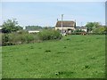
2
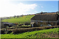
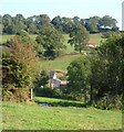
Higher Pithayne Farm from near Peacross Farm
A view from Yarcombe Bridleway 31 where it leaves the driveway to Peacross Farm. Higher Pithayne Farm is centre photo on the upper slopes of the Yarty valley (beyond).
Image: © Derek Harper
Taken: 21 Sep 2006
0.06 miles
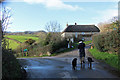
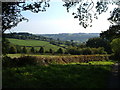
7
Pithayne Farms
Pasture and dairy farms near Yarcombe.
Image: © Richard Webb
Taken: 20 Apr 2011
0.15 miles
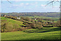
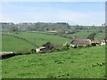
9
Whitehorn's Farm
A glimpse through field boundaries of a farm in a fold of the Yarty valley, north of Yarcombe, with a barn beyond Yarcombe Bridleway 31 (from which this was taken). Above is Peacross Covert.
Image: © Derek Harper
Taken: 21 Sep 2006
0.22 miles