IMAGES TAKEN NEAR TO
Luppitt, HONITON, EX14 4UE
Introduction
This page details the photographs taken nearby to EX14 4UE by members of the Geograph project.
The Geograph project started in 2005 with the aim of publishing, organising and preserving representative images for every square kilometre of Great Britain, Ireland and the Isle of Man.

There are currently over 7.5m images from over14,400 individuals and you can help contribute to the project by visiting https://www.geograph.org.uk
Image Map
Images are licensed for reuse under creativecommons.org/licenses/by-sa/2.0
Notes
- Clicking on the map will re-center to the selected point.
- The higher the marker number, the further away the image location is from the centre of the postcode.
Image Listing (9 Images Found)
Images are licensed for reuse under creativecommons.org/licenses/by-sa/2.0
Image
Details
Distance
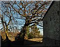
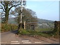
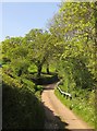
2
Luppitt: east from Greenway Farm
Near the cross roads where a left turn finds a narrow lane to Luppitt village; straight on for Luppitt Mill and right for Shelvin
Image: © Martin Bodman
Taken: 7 Sep 2005
0.07 miles
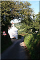
3
Luppitt : Greenway Lane
Looking along Greenway Lane alongside Corner House.
Image: © Lewis Clarke
Taken: 31 Dec 2022
0.12 miles
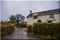
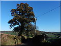
4
Luppitt: north to Luppitt village
Luppitt church stands amongst trees, left. In the valley, right, runs a tributary of the river Otter
Image: © Martin Bodman
Taken: 7 Sep 2005
0.12 miles
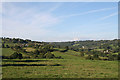
5
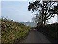
Road to Penny Thorn Cross
The rounded top of Dumpdon Hill fills the skyline
Image: © David Smith
Taken: 4 Mar 2013
0.14 miles
6
View from crossroads near Greenway
Looking east towards Hartridge and houses at Beacon
Image: © David Smith
Taken: 4 Mar 2013
0.14 miles
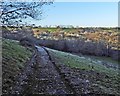
9
Lane near Penny Thorn Cross
The lane to Luppitt runs briefly alongside a small stream, with a wooden parapet for protection.
Image: © Derek Harper
Taken: 22 May 2012
0.22 miles