IMAGES TAKEN NEAR TO
Awliscombe, HONITON, EX14 3QB
Introduction
This page details the photographs taken nearby to EX14 3QB by members of the Geograph project.
The Geograph project started in 2005 with the aim of publishing, organising and preserving representative images for every square kilometre of Great Britain, Ireland and the Isle of Man.

There are currently over 7.5m images from over14,400 individuals and you can help contribute to the project by visiting https://www.geograph.org.uk
Image Map
Images are licensed for reuse under creativecommons.org/licenses/by-sa/2.0
Notes
- Clicking on the map will re-center to the selected point.
- The higher the marker number, the further away the image location is from the centre of the postcode.
Image Listing (10 Images Found)
Images are licensed for reuse under creativecommons.org/licenses/by-sa/2.0
Image
Details
Distance
1
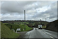
On the A373 heading east, sign for A. R. Boland Ltd
Image: © Rob Purvis
Taken: 2 Feb 2023
0.06 miles
2
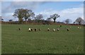
Sheep near Awliscombe
Not keen on having their photo taken. This field is above the stretch of A373 shown in Image
Image: © Derek Harper
Taken: 26 Jan 2012
0.10 miles
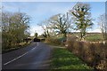
3
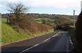
A373 near Godford Farm
Looking down the main road as it descends to cross the River Wolf. On the far side, the land rises to St Cyres' Hill.
Image: © Derek Harper
Taken: 26 Jan 2012
0.14 miles
4
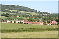
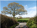
Awliscombe: towards Hunthayes Farm
Looking east across the A373 Honiton-Cullompton road - beyond the first hedge -to the farm. St Cyres Hill forms the backdrop. A buzzard appears to be sitting atop the telegraph pole in the centre of the image
Image: © Martin Bodman
Taken: 24 Jun 2006
0.17 miles
5
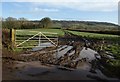
Field near Hunthay Farm
Taken at the foot of the hill shown Image, looking to the right, with a very muddy entrance. In the distance is St Cyres' Hill.
Image: © Derek Harper
Taken: 26 Jan 2012
0.20 miles
6
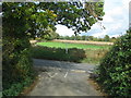
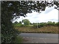
Minor road meets the A373 at Buckerell Cross
Image: © Sarah Charlesworth
Taken: 30 Oct 2010
0.20 miles
7
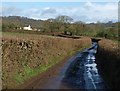
Lane past New Park Farm
From the gateway where Image was taken. New Park Farm is in Image The trees ahead mark the crossing of a small tributary of the River Wolf.
Image: © Derek Harper
Taken: 26 Jan 2012
0.20 miles
9
Buckerell Cross on the A373
The crossroads is slightly staggered. It is not named on the OS map, but the signpost preserves the name.
Image: © David Smith
Taken: 20 Aug 2012
0.23 miles
10
A373 at Godford Bridge
The main road curves away from the bridge over the Wolf, from which Image was taken. A curious sculpture on the right, recycling bits of piping into a humanoid figure.
Image: © Derek Harper
Taken: 26 Jan 2012
0.23 miles