IMAGES TAKEN NEAR TO
Awliscombe, HONITON, EX14 3NU
Introduction
This page details the photographs taken nearby to EX14 3NU by members of the Geograph project.
The Geograph project started in 2005 with the aim of publishing, organising and preserving representative images for every square kilometre of Great Britain, Ireland and the Isle of Man.

There are currently over 7.5m images from over14,400 individuals and you can help contribute to the project by visiting https://www.geograph.org.uk
Image Map
Images are licensed for reuse under creativecommons.org/licenses/by-sa/2.0
Notes
- Clicking on the map will re-center to the selected point.
- The higher the marker number, the further away the image location is from the centre of the postcode.
Image Listing (3 Images Found)
Images are licensed for reuse under creativecommons.org/licenses/by-sa/2.0
Image
Details
Distance
1
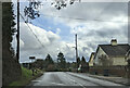
Land Rover Experience sign and houses on the east side of Awliscombe, on the A373
Image: © Rob Purvis
Taken: 2 Feb 2023
0.06 miles
2
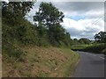
Roadside verge near Awliscombe House
The verge and hedge have been managed so as to allow vehicles from a side road (the photographer's position) to see traffic on the main road.
Image: © David Smith
Taken: 20 Aug 2012
0.10 miles
3
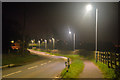
East Devon : The A373
Looking along the A373 as it heads through East Devon.
Image: © Lewis Clarke
Taken: 8 Apr 2018
0.17 miles