IMAGES TAKEN NEAR TO
Gittisham, HONITON, EX14 3AU
Introduction
This page details the photographs taken nearby to EX14 3AU by members of the Geograph project.
The Geograph project started in 2005 with the aim of publishing, organising and preserving representative images for every square kilometre of Great Britain, Ireland and the Isle of Man.

There are currently over 7.5m images from over14,400 individuals and you can help contribute to the project by visiting https://www.geograph.org.uk
Image Map
Images are licensed for reuse under creativecommons.org/licenses/by-sa/2.0
Notes
- Clicking on the map will re-center to the selected point.
- The higher the marker number, the further away the image location is from the centre of the postcode.
Image Listing (4 Images Found)
Images are licensed for reuse under creativecommons.org/licenses/by-sa/2.0
Image
Details
Distance
1
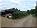
Barn at Sherman's Farm and road to Westgate
Image: © David Smith
Taken: 24 May 2011
0.12 miles
2
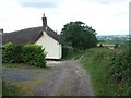
Houstain's House on Landscore Lane
The lane drops from the woods on East Hill. Beyond the house it is not regularly used by vehicles.
Image: © David Smith
Taken: 24 May 2011
0.13 miles
3

Minor road to Westgate
The steep road drops from the woods on East Hill into farmland and bright sunlight
Image: © David Smith
Taken: 24 May 2011
0.24 miles
