IMAGES TAKEN NEAR TO
Lower Brand Lane, HONITON, EX14 2AA
Introduction
This page details the photographs taken nearby to Lower Brand Lane, EX14 2AA by members of the Geograph project.
The Geograph project started in 2005 with the aim of publishing, organising and preserving representative images for every square kilometre of Great Britain, Ireland and the Isle of Man.

There are currently over 7.5m images from over14,400 individuals and you can help contribute to the project by visiting https://www.geograph.org.uk
Image Map
Images are licensed for reuse under creativecommons.org/licenses/by-sa/2.0
Notes
- Clicking on the map will re-center to the selected point.
- The higher the marker number, the further away the image location is from the centre of the postcode.
Image Listing (103 Images Found)
Images are licensed for reuse under creativecommons.org/licenses/by-sa/2.0
Image
Details
Distance
1
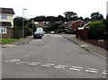
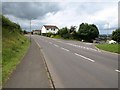
Lower Brand Lane, Honiton
Ascending from Littletown Road.
Image: © Jaggery
Taken: 1 Aug 2017
0.03 miles
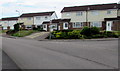
2
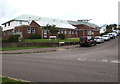
Modern suburbia
New suburban dwellings, the outer edge of a housing estate in Honiton.
Image: © Tony Atkin
Taken: 30 Aug 2005
0.05 miles
3
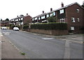
Marlpits Lane houses, Honiton
The corner of Lower Brand Lane http://www.geograph.org.uk/photo/5483641 is on the right.
Image: © Jaggery
Taken: 1 Aug 2017
0.05 miles
4
Haydons Park, Honiton
The road named Haydons Park viewed across Marlpits Lane. Honiton Surgery http://www.geograph.org.uk/photo/5484465 is on the left.
Image: © Jaggery
Taken: 1 Aug 2017
0.07 miles
5

Honiton : Honiton Scenery
Looking out across the town of Honiton.
Image: © Lewis Clarke
Taken: 8 Apr 2018
0.07 miles
6
The Co-operative Funeralcare, Honiton
On the corner of Littletown Road and Lower Brand Lane.
Image: © Jaggery
Taken: 1 Aug 2017
0.08 miles
7
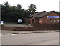
Honiton Surgery, Honiton
The Haydons Park side of the medical surgery on the corner of Marlpits Lane.
Image: © Jaggery
Taken: 1 Aug 2017
0.08 miles
8

Honiton : Footpath
A footpath heading down from Weatherill Road down to Buttery Close.
Image: © Lewis Clarke
Taken: 8 Apr 2018
0.09 miles
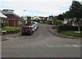
9
Littletown Road houses, Honiton
Houses on the south side of Littletown Road. The Co-operative Funeralcare http://www.geograph.org.uk/photo/5483632 is in the background.
Image: © Jaggery
Taken: 1 Aug 2017
0.09 miles
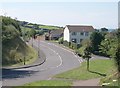
10
Junction of Weatherill Road with Lower Brand Lane, Honiton
Another view of the junction shown in Image Weatherill Road, the main road here, forms a loop around the southern edge of the estates.
Image: © Derek Harper
Taken: 18 Jul 2009
0.09 miles