1
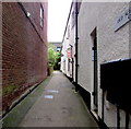
Chapel Street, Honiton
Dead-end street extending for 90 metres from the east side of New Street.
Image: © Jaggery
Taken: 1 Aug 2017
0.02 miles
2
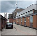
Honiton Delivery Office
Royal Mail site set back from Chapel Street.
Image: © Jaggery
Taken: 1 Aug 2017
0.02 miles
3
Up Chapel Street, Honiton
Chapel Street ascends from New Street.
Ahead are Honiton Methodist Church http://www.geograph.org.uk/photo/5503516 and Honiton Delivery Office. http://www.geograph.org.uk/photo/5503530
Image: © Jaggery
Taken: 1 Aug 2017
0.02 miles
4
Old School House Court, Honiton
Lane on the south side of High Street. The blue plaque http://www.geograph.org.uk/photo/5485700 behind the camera records that the lane formerly led to the dormitories for the boys of Allhallows School.
Image: © Jaggery
Taken: 1 Aug 2017
0.03 miles
5
Honiton Telephone Exchange
Set back from Chapel Street, Honiton Exchange (code WWHONI) provides broadband and telephone services for about 5,850 residential premises and 400 non-residential premises.
Image: © Jaggery
Taken: 1 Aug 2017
0.03 miles
6
Honiton High Street
Taken on a very busy market day. The road is full of traffic, delivery vans and market stalls.
Image: © Tony Atkin
Taken: 30 Aug 2005
0.04 miles
7
Robson House, Chapel Street, Honiton
Single-storey office building viewed on August 1st 2017.
Names in view are Geraldine Coates Accounting and Ultim8 Construction Limited.
Image: © Jaggery
Taken: 1 Aug 2017
0.04 miles
8
Honiton Methodist Church, Chapel Street, Honiton
Viewed on August 1st 2017. Honiton Methodist Church was previously in this http://www.geograph.org.uk/photo/5503504 building 40 metres away, on the corner of New Street. The church is part of the Exeter Coast & Country Circuit of the Methodist Church.
Image: © Jaggery
Taken: 1 Aug 2017
0.04 miles
9
Honiton: New Street
Looking towards W H Smith, at 109 High Street. Lloyds TSB – now incorporating HBOS – is on the corner of New Street and High Street, its end wall on the extreme left – at 82 High Street. Behind the photographer is 'Fishmongers', a relative rarity in this part of Devon. While there is a fishmonger in Wellington, Tiverton and Cullompton rely on a mobile van from Newton Abbot
Image: © Martin Bodman
Taken: 8 Apr 2009
0.04 miles
10
Buildings along Honiton High Street
A good sequence of facades along the south side of Honiton's main street, culminating in number 62, the C18 brick building on the right http://www.imagesofengland.org.uk/Details/Default.aspx?id=442952&mode=adv . What a shame about the modern building to its right.
Image: © Derek Harper
Taken: 15 May 2010
0.04 miles


