IMAGES TAKEN NEAR TO
Trinity Hill Road, AXMINSTER, EX13 8TB
Introduction
This page details the photographs taken nearby to Trinity Hill Road, EX13 8TB by members of the Geograph project.
The Geograph project started in 2005 with the aim of publishing, organising and preserving representative images for every square kilometre of Great Britain, Ireland and the Isle of Man.

There are currently over 7.5m images from over14,400 individuals and you can help contribute to the project by visiting https://www.geograph.org.uk
Image Map
Images are licensed for reuse under creativecommons.org/licenses/by-sa/2.0
Notes
- Clicking on the map will re-center to the selected point.
- The higher the marker number, the further away the image location is from the centre of the postcode.
Image Listing (10 Images Found)
Images are licensed for reuse under creativecommons.org/licenses/by-sa/2.0
Image
Details
Distance
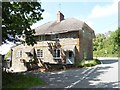

3

House on Trinity Hill Rd
This house sits right on the junction of Trinity Hill Rd and Woodhouse Lane. The road on the right goes up to Trinity Hill and the one ahead goes to Musbury.
Image: © Nigel Mykura
Taken: 27 Jan 2017
0.06 miles

6
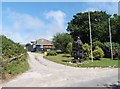
Bear statue at the entrance to 'Fortis'
Image: © Roger Cornfoot
Taken: 22 Jun 2020
0.08 miles
8
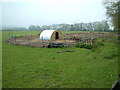
Hart Grove Farm
Hart Grove Farm is east of Musbury, Devon. This looks as though it is pig farming on a small scale.
Image: © Stuart Buchan
Taken: 6 May 2006
0.09 miles
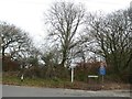
9
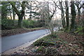
Woodhouse Lane
This is part of the minor road from Musbury to Uplyme just after it has crossed Trinity Hill Rd at the saddle between Shapwick Hill and Trinity Hill.
Image: © Nigel Mykura
Taken: 27 Jan 2017
0.13 miles
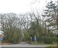
10
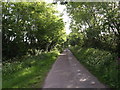
Lane up Hartgrove Hill
The lane climbs away from Hartgrove Farm and the dismantled railway.
Image: © Derek Harper
Taken: 22 May 2007
0.23 miles