IMAGES TAKEN NEAR TO
Membury, AXMINSTER, EX13 7UD
Introduction
This page details the photographs taken nearby to EX13 7UD by members of the Geograph project.
The Geograph project started in 2005 with the aim of publishing, organising and preserving representative images for every square kilometre of Great Britain, Ireland and the Isle of Man.

There are currently over 7.5m images from over14,400 individuals and you can help contribute to the project by visiting https://www.geograph.org.uk
Image Map
Images are licensed for reuse under creativecommons.org/licenses/by-sa/2.0
Notes
- Clicking on the map will re-center to the selected point.
- The higher the marker number, the further away the image location is from the centre of the postcode.
Image Listing (3 Images Found)
Images are licensed for reuse under creativecommons.org/licenses/by-sa/2.0
Image
Details
Distance
1
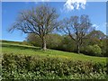
Trees at Webble Green
With Webble Green Copse behind up the hill.
Image: © Derek Harper
Taken: 16 May 2013
0.07 miles
2
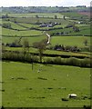
Sheep pasture, Webble Green
Just the first 160 metres of this view are in square. Fields beyond drop into the Yarty valley. At upper centre is Trimshayes Farm with, to its left, the stretch of steep lane shown in Image]
Image: © Derek Harper
Taken: 16 May 2013
0.08 miles
3

Road climbs out of the Yarty valley
Image: © Sarah Charlesworth
Taken: 3 Feb 2011
0.19 miles