IMAGES TAKEN NEAR TO
Kilmington, AXMINSTER, EX13 7RD
Introduction
This page details the photographs taken nearby to EX13 7RD by members of the Geograph project.
The Geograph project started in 2005 with the aim of publishing, organising and preserving representative images for every square kilometre of Great Britain, Ireland and the Isle of Man.

There are currently over 7.5m images from over14,400 individuals and you can help contribute to the project by visiting https://www.geograph.org.uk
Image Map
Images are licensed for reuse under creativecommons.org/licenses/by-sa/2.0
Notes
- Clicking on the map will re-center to the selected point.
- The higher the marker number, the further away the image location is from the centre of the postcode.
Image Listing (26 Images Found)
Images are licensed for reuse under creativecommons.org/licenses/by-sa/2.0
Image
Details
Distance
1
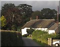
Old Vealhays, Kilmington
A very similar view to Image at a different season. The thatched former farmhouse is a C16 open hall house http://list.english-heritage.org.uk/resultsingle.aspx?uid=1333571&searchtype=mapsearch . This is Vealhays Lane.
Image: © Derek Harper
Taken: 15 Sep 2012
0.04 miles
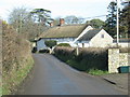
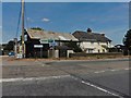
3
Thatched Dwellings, Kilmington
Situated on the lane leading to Coryton, this is a view of two traditional thatched dwellings in the village of Kilmington.
Image: © Mike Crowe
Taken: 18 Jun 2005
0.10 miles
5

The Cross, Kilmington
Looking from Church Road across the A35 to Crosslands Cottage. On the left is the scene in Image
Image: © Derek Harper
Taken: 15 Sep 2012
0.11 miles
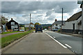
6
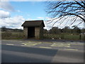
Kilmington : Bus Station on Gammon Hills
A bus shelter on the A35 near Kilmington.
Image: © Lewis Clarke
Taken: 12 Mar 2010
0.11 miles
7

The Cross, Kilmington
Image] from the west. Down the A35 is the petrol station shown in http://www.geograph.org.uk/search.php?i=36429058 .
Image: © Derek Harper
Taken: 15 Sep 2012
0.11 miles
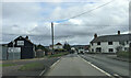
8

Kilmington : Gammons Hill A35
A road between Honiton and Dorchester near the Texaco Petrol Station.
Image: © Lewis Clarke
Taken: 12 Mar 2010
0.11 miles
9
On the A35, Gammons Hill, Kilmington, heading east
Image: © Rob Purvis
Taken: 2 Feb 2023
0.12 miles