IMAGES TAKEN NEAR TO
Whitford, AXMINSTER, EX13 7NW
Introduction
This page details the photographs taken nearby to EX13 7NW by members of the Geograph project.
The Geograph project started in 2005 with the aim of publishing, organising and preserving representative images for every square kilometre of Great Britain, Ireland and the Isle of Man.

There are currently over 7.5m images from over14,400 individuals and you can help contribute to the project by visiting https://www.geograph.org.uk
Image Map
Images are licensed for reuse under creativecommons.org/licenses/by-sa/2.0
Notes
- Clicking on the map will re-center to the selected point.
- The higher the marker number, the further away the image location is from the centre of the postcode.
Image Listing (49 Images Found)
Images are licensed for reuse under creativecommons.org/licenses/by-sa/2.0
Image
Details
Distance
1

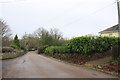
Whitford : Whitford Road
Whitford Road with the village welcome sign on the left.
Image: © Lewis Clarke
Taken: 16 Feb 2012
0.03 miles
2
Lane into Whitford
This is the minor road that comes from Kilmington and it joins the minor road from Musbury to Shute at the eastern end of the village.
Image: © Nigel Mykura
Taken: 2 Jan 2018
0.03 miles
3
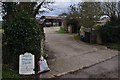
Whitford : Pump Farm
Pump Farm on Whitford Road with a sign promoting manure for 50p a bag.
Image: © Lewis Clarke
Taken: 16 Feb 2012
0.06 miles
4
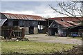
Whitford : Pump Farm Barns
Looking towards old looking barns from Whitford Road.
Image: © Lewis Clarke
Taken: 16 Feb 2012
0.07 miles
5
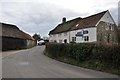
Whitford : Whitford Road
A signpost at the road junction with houses behind it.
Image: © Lewis Clarke
Taken: 16 Feb 2012
0.09 miles
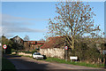
6

Road entering Whitford
Comparable with Image On the left is Parklands, listed "for group value" http://list.english-heritage.org.uk/resultsingle.aspx?uid=1171070&searchtype=mapsearch . On the right are outbuildings of Pump Farm. Visible up the road is the hipped roof of the stables at the former Backside Farm http://list.english-heritage.org.uk/resultsingle.aspx?uid=1098402&searchtype=mapsearch .
Image: © Derek Harper
Taken: 15 Sep 2012
0.09 miles
7
Shute: farm at Whitford
Looking north-northwest. The buildings form part of Pump Farm, which has existed here for more than 400 years.
Image: © Martin Bodman
Taken: 16 Dec 2006
0.11 miles
8
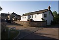
Hampton Court, Whitford
The name of this new development of houses in the village may seem slightly pretentious, but Hampton is a local place-name.
Image: © Derek Harper
Taken: 22 May 2007
0.12 miles
9
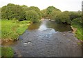
River Axe at Whitford
Looking upstream from Whitford Bridge; see also Image Hampton Goyle flows into the river by the bushes on the left, and a (possibly THE) ford crosses amongst the rocky rapids beyond.
Image: © Derek Harper
Taken: 15 Sep 2012
0.13 miles
10
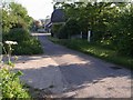
Ford on Hampton Lane, Whitford
Presumably the ford that gives the village its name. The Hampton Goyle runs beneath the lane, but clearly across it in times of flood. This view looks north away from the main street.
Image: © Derek Harper
Taken: 22 May 2007
0.13 miles