IMAGES TAKEN NEAR TO
Holy City, AXMINSTER, EX13 7JZ
Introduction
This page details the photographs taken nearby to EX13 7JZ by members of the Geograph project.
The Geograph project started in 2005 with the aim of publishing, organising and preserving representative images for every square kilometre of Great Britain, Ireland and the Isle of Man.

There are currently over 7.5m images from over14,400 individuals and you can help contribute to the project by visiting https://www.geograph.org.uk
Image Map
Images are licensed for reuse under creativecommons.org/licenses/by-sa/2.0
Notes
- Clicking on the map will re-center to the selected point.
- The higher the marker number, the further away the image location is from the centre of the postcode.
Image Listing (19 Images Found)
Images are licensed for reuse under creativecommons.org/licenses/by-sa/2.0
Image
Details
Distance
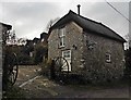
3
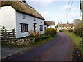
Chardstock: Cottage near Whitehouse Farm
Looking west-north-west on the lane from Holy City
Image: © Martin Bodman
Taken: 30 Apr 2006
0.05 miles
6
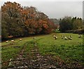
Field near Holy City
On the north side of the road to Ten Acre Gate, this is one of a network of small bocage fields entirely surrounded by trees. On the left is a wood.
Image: © Derek Harper
Taken: 16 May 2013
0.13 miles
7
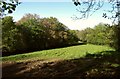
Field west of Holy City
On the opposite side of the lane to Image
Image: © Derek Harper
Taken: 16 May 2013
0.16 miles
9
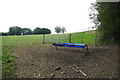
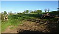
Fields near Woonton Farm
These pasture fields are on the opposite side of the road that runs from Holy City to Ten Acre Gate.
Image: © Nigel Mykura
Taken: 7 Aug 2015
0.18 miles
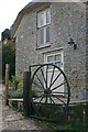
10
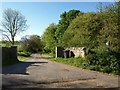
Entrance to Woonton Farm
Chardstock Bridleway 19 follows this driveway between the gateposts as it leaves the road between Ten Acre Gate and Holy City. Open woodland is on the right.
Image: © Derek Harper
Taken: 16 May 2013
0.18 miles