IMAGES TAKEN NEAR TO
Dalwood, AXMINSTER, EX13 7HT
Introduction
This page details the photographs taken nearby to EX13 7HT by members of the Geograph project.
The Geograph project started in 2005 with the aim of publishing, organising and preserving representative images for every square kilometre of Great Britain, Ireland and the Isle of Man.

There are currently over 7.5m images from over14,400 individuals and you can help contribute to the project by visiting https://www.geograph.org.uk
Image Map
Images are licensed for reuse under creativecommons.org/licenses/by-sa/2.0
Notes
- Clicking on the map will re-center to the selected point.
- The higher the marker number, the further away the image location is from the centre of the postcode.
Image Listing (8 Images Found)
Images are licensed for reuse under creativecommons.org/licenses/by-sa/2.0
Image
Details
Distance
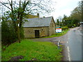
1
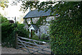
Dalwood: Telegraph Cottage
Looking south west by the road from Axminster to the A30 via Stockland Hill. Telegraph Cottage is probably very close to the site of Dalwood Common station on the manned signalling telegraph line from the Admiralty in London to Devonport. It functioned from 1806 to 1814, during the Napoleonic wars. It seems somewhat surprising that the station is this far south at this point, but the Plymouth line was an extension of one to Portsmouth which had opened in 1796. Today another communications system operates a couple of field lengths away: the high mast of Stockland Hill TV Station is a landmark for miles around
Image: © Martin Bodman
Taken: 1 Sep 2006
0.00 miles
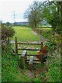
2
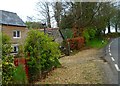
Orange Way in Devon and Torbay (451)
I looked back uphill at Telegraph Cottage. There is a weathercat in the garden.
Image: © Shazz
Taken: 18 Apr 2012
0.00 miles
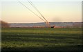
3
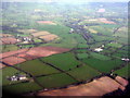
Stockland Hill
An aerial view from east of Honiton. The mast is Stockland Hill TV and radio transmitter, which has been there since 1961 serving the east Devon and West Dorset http://en.wikipedia.org/wiki/Stockland_Hill_transmitting_station.
Image: © M J Richardson
Taken: 11 Jan 2015
0.13 miles
5
Orange Way in Devon and Torbay (453)
It's back to muddiness I see.
Image: © Shazz
Taken: 18 Apr 2012
0.23 miles
6
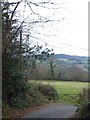
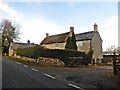
Hayne Lane and the valley of the Umborne
Hayne Lane drops through Jeremy's Wood on the west slope of Stockland Hill. Like many roads down the slope, this drops gently across the slope, before turning to approach the river/stream more directly. The gate leads to a field at the foot of the woodland.
Image: © David Smith
Taken: 6 Dec 2012
0.23 miles
7
Mast support, Stockland Hill
There seem to be six anchor points for the mast stays; this is the southernmost, in the field shown in Image
Image: © Derek Harper
Taken: 5 Dec 2012
0.23 miles
8
Orange Way in Devon and Torbay (452)
The footpath signed on the left is taken at Lamb Farm.
Image: © Shazz
Taken: 18 Apr 2012
0.25 miles