IMAGES TAKEN NEAR TO
Dalwood, AXMINSTER, EX13 7HP
Introduction
This page details the photographs taken nearby to EX13 7HP by members of the Geograph project.
The Geograph project started in 2005 with the aim of publishing, organising and preserving representative images for every square kilometre of Great Britain, Ireland and the Isle of Man.

There are currently over 7.5m images from over14,400 individuals and you can help contribute to the project by visiting https://www.geograph.org.uk
Image Map
Images are licensed for reuse under creativecommons.org/licenses/by-sa/2.0
Notes
- Clicking on the map will re-center to the selected point.
- The higher the marker number, the further away the image location is from the centre of the postcode.
Image Listing (4 Images Found)
Images are licensed for reuse under creativecommons.org/licenses/by-sa/2.0
Image
Details
Distance
1
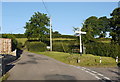
Crossroads near Brimblecombe farm
The finger posts on this green triangle with its park bench seating, point the way to Honiton, Shute, Hawley Bottom and Dalwood.
Image: © Nigel Mykura
Taken: 7 Aug 2015
0.15 miles
2
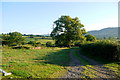
Track to Brimblecombe Farm
This is a private farm track . There is also a public road going through the middle of the farm and when in the middle of the farm it is impossible to tell that there is a public road through it.
Image: © Nigel Mykura
Taken: 7 Aug 2015
0.15 miles
3
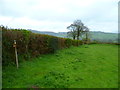
Orange Way in Devon and Torbay (459)
In the foreground is a waymark for a path junction.
Image: © Shazz
Taken: 18 Apr 2012
0.20 miles
4
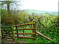
Orange Way in Devon and Torbay (458)
Here's another gate between fields.
Image: © Shazz
Taken: 18 Apr 2012
0.23 miles