IMAGES TAKEN NEAR TO
Burridge, AXMINSTER, EX13 7DF
Introduction
This page details the photographs taken nearby to EX13 7DF by members of the Geograph project.
The Geograph project started in 2005 with the aim of publishing, organising and preserving representative images for every square kilometre of Great Britain, Ireland and the Isle of Man.

There are currently over 7.5m images from over14,400 individuals and you can help contribute to the project by visiting https://www.geograph.org.uk
Image Map
Images are licensed for reuse under creativecommons.org/licenses/by-sa/2.0
Notes
- Clicking on the map will re-center to the selected point.
- The higher the marker number, the further away the image location is from the centre of the postcode.
Image Listing (6 Images Found)
Images are licensed for reuse under creativecommons.org/licenses/by-sa/2.0
Image
Details
Distance
1
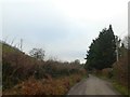
Road south-west of Burridge, following the valley of the River Kit
Image: © David Smith
Taken: 30 Dec 2019
0.05 miles
2

View from Burridge
Looking south from the lane in front of Burridge Farm, across the valley of a tributary of the River Kit.
Image: © Derek Harper
Taken: 22 May 2007
0.06 miles
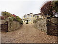
3

Road to Burridge
The road extends to Burridge Farm; after that, a footpath runs past the woods of Burridge Common along an old lane
Image: © David Smith
Taken: 30 Dec 2019
0.11 miles

6

County boundary
The county boundary between Devon (left) and Somerset (right) runs along this lane; it is probably fair to say that a slight majority of this photo is in Somerset, but that it was taken in Devon. The lane runs from Burridge Cross to the hamlet of Burridge, partly visible in the background (Burridge Farmhouse). The dip in the road marks a shallow valley which deepens as it drops away to the left to join the valley through Hook.
Image: © Derek Harper
Taken: 22 May 2007
0.21 miles