IMAGES TAKEN NEAR TO
Hawkchurch, AXMINSTER, EX13 5UT
Introduction
This page details the photographs taken nearby to EX13 5UT by members of the Geograph project.
The Geograph project started in 2005 with the aim of publishing, organising and preserving representative images for every square kilometre of Great Britain, Ireland and the Isle of Man.

There are currently over 7.5m images from over14,400 individuals and you can help contribute to the project by visiting https://www.geograph.org.uk
Image Map
Images are licensed for reuse under creativecommons.org/licenses/by-sa/2.0
Notes
- Clicking on the map will re-center to the selected point.
- The higher the marker number, the further away the image location is from the centre of the postcode.
Image Listing (7 Images Found)
Images are licensed for reuse under creativecommons.org/licenses/by-sa/2.0
Image
Details
Distance
1
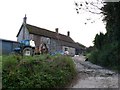
Hawkmoor Farm
The farm is at the junction of Hawkmoor Hill and Berry Lane just west of Marshwood. At this point the road is part of The Liberty Trail long distance footpath which runs south from here up the hill to Lambert's Castle.
Image: © Nigel Mykura
Taken: 25 Oct 2009
0.01 miles
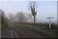
5
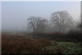
Wessex Ridgeway between Hawkmoor and Gashay Farm
Heading east away from Hawkmoor Hill below Lambert's Castle - careful attention to the map required in the winter mist.
The trail slips into Devon, at this juncture - but only for the briefest of visits.
Image: © Chris Heaton
Taken: 24 Jan 2017
0.14 miles
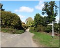
6
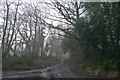
Hawkmoor Hill
The Wessex Ridgeway takes a muddy descent from Lambert's Castle
Image: © Tim Heaton
Taken: 24 Jan 2017
0.19 miles
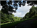
7
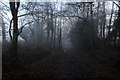
Misty Morning on Hawkmoor Hill
Following the muddy track northwards, adopted by the Wessex Ridgeway
Image: © Chris Heaton
Taken: 24 Jan 2017
0.23 miles