IMAGES TAKEN NEAR TO
Tigers Way, AXMINSTER, EX13 5TG
Introduction
This page details the photographs taken nearby to Tigers Way, EX13 5TG by members of the Geograph project.
The Geograph project started in 2005 with the aim of publishing, organising and preserving representative images for every square kilometre of Great Britain, Ireland and the Isle of Man.

There are currently over 7.5m images from over14,400 individuals and you can help contribute to the project by visiting https://www.geograph.org.uk
Image Map
Images are licensed for reuse under creativecommons.org/licenses/by-sa/2.0
Notes
- Clicking on the map will re-center to the selected point.
- The higher the marker number, the further away the image location is from the centre of the postcode.
Image Listing (70 Images Found)
Images are licensed for reuse under creativecommons.org/licenses/by-sa/2.0
Image
Details
Distance
1

Tigers Way, Axminster
Cul-de-sac on the north side of Sector Lane.
There is no apostrophe in TIGERS on either of the two street name signs.
Image: © Jaggery
Taken: 9 Mar 2017
0.04 miles
2

Cridlake, Axminster
Cridlake is a cul-de-sac on the north side of Sector Lane.
Image: © Jaggery
Taken: 9 Mar 2017
0.06 miles
3

Tiger House, Axminster
Tiger House is the semi-detached house behind the street name sign,
on the corner of Tigers Way and Sector Lane.
Image: © Jaggery
Taken: 9 Mar 2017
0.07 miles
4

Sector Lane houses, Axminster
On the north side of Sector Lane, east of the Tigers Way junction. http://www.geograph.org.uk/photo/5306355
Image: © Jaggery
Taken: 9 Mar 2017
0.08 miles
5
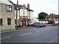
The Lamb Inn, Axminster
The pub dates from 1899.
Image: © Maigheach-gheal
Taken: 9 Jul 2009
0.09 miles
6

X54 bus, Lyme Road, Axminster
The First Wessex bus on route X54 from Lyme Regis descends Lyme Road towards
Axminster town centre and the X54 terminus outside Axminster railway station.
Image: © Jaggery
Taken: 9 Mar 2017
0.10 miles
7

Benchmark on #1 Lyme Road
Ordnance Survey cut mark benchmark described on the Bench Mark Database at http://www.bench-marks.org.uk/bm45444
Image: © Roger Templeman
Taken: 20 Sep 2012
0.10 miles
8

Lyme Road heading towards the centre of Axminster
Image: © Eirian Evans
Taken: 28 Oct 2021
0.10 miles
9
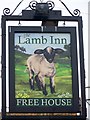
Sign for the Lamb Inn, Axminster
The lamb is of great Christian significance that to the passage in John 1:29 which reads "Behold the Lamb of God, which taketh away the sins of the world", thus equating the lamb with Jesus Christ. As a saintly emblem a lamb accompanies John the Baptist, St Agnes, St Catherine, St Genevieve and St Regina.
Image: © Maigheach-gheal
Taken: 9 Jul 2009
0.10 miles
10
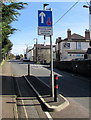
Traffic calming on Lyme Road, Axminster
Vehicles on this side of the B3261 Lyme Road have priority through the narrowed section ahead.
Cyclists can use the lane on the left. The Lamb Inn is in the background.
Image: © Jaggery
Taken: 9 Mar 2017
0.10 miles