IMAGES TAKEN NEAR TO
Woodside Close, Crewkerne Road, AXMINSTER, EX13 5TE
Introduction
This page details the photographs taken nearby to Woodside Close, Crewkerne Road, EX13 5TE by members of the Geograph project.
The Geograph project started in 2005 with the aim of publishing, organising and preserving representative images for every square kilometre of Great Britain, Ireland and the Isle of Man.

There are currently over 7.5m images from over14,400 individuals and you can help contribute to the project by visiting https://www.geograph.org.uk
Image Map
Images are licensed for reuse under creativecommons.org/licenses/by-sa/2.0
Notes
- Clicking on the map will re-center to the selected point.
- The higher the marker number, the further away the image location is from the centre of the postcode.
Image Listing (16 Images Found)
Images are licensed for reuse under creativecommons.org/licenses/by-sa/2.0
Image
Details
Distance

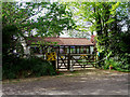
2
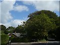
Woodside Close, Monkton Wyld Cross
The road sign is buried in the shade of the tree - making the name quite apt
Image: © David Smith
Taken: 20 Aug 2019
0.03 miles
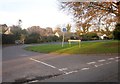
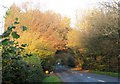
3

B3165 at Monkton Wyld Cross
Taken from beside the junction, where two arms of the B road separate, a little confusingly. This arm, Crewkerne Road, is heading into Raymond's Hill, with junctions ahead, the first with Woodside Close, and the second with Green Lane (left) and Cook's Lane. The county boundary between Dorset and Devon (right) runs along this stretch of the B3165, and then turns left to follow Green Lane.
Image: © Derek Harper
Taken: 23 Nov 2013
0.04 miles
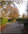
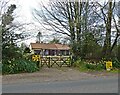
4
Axe Valley Close, Raymond's Hill
A small cul-de-sac off Cook's Lane.
Image: © Derek Harper
Taken: 23 Nov 2013
0.04 miles
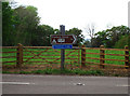
5
Cook's Lane
The lane passes Image] on the left. The sign warns of the approaching junction with the B3165.
Image: © Derek Harper
Taken: 23 Nov 2013
0.04 miles
7
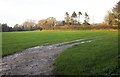
Field by Crewkerne Road
The field beside the stretch of the B3165 shown in Image On the left is the edge of Bever Batch, woodland at the head of a steep valley.
Image: © Derek Harper
Taken: 23 Nov 2013
0.12 miles
10
B3165 near Monkton Wyld Cross
The road to Crewkerne runs along the county boundary between Devon (left) and Dorset.
Image: © Derek Harper
Taken: 23 Nov 2013
0.17 miles