IMAGES TAKEN NEAR TO
Lower Mead, AXMINSTER, EX13 5FP
Introduction
This page details the photographs taken nearby to Lower Mead, EX13 5FP by members of the Geograph project.
The Geograph project started in 2005 with the aim of publishing, organising and preserving representative images for every square kilometre of Great Britain, Ireland and the Isle of Man.

There are currently over 7.5m images from over14,400 individuals and you can help contribute to the project by visiting https://www.geograph.org.uk
Image Map
Images are licensed for reuse under creativecommons.org/licenses/by-sa/2.0
Notes
- Clicking on the map will re-center to the selected point.
- The higher the marker number, the further away the image location is from the centre of the postcode.
Image Listing (44 Images Found)
Images are licensed for reuse under creativecommons.org/licenses/by-sa/2.0
Image
Details
Distance
1

Orange Way in Devon and Torbay (503)
This was the way to escape from the horror.
Image: © Shazz
Taken: 18 Apr 2012
0.09 miles

3

Public footpath to Sector Park
Once an open field now fenced footpath with site for new houses.
Image: © Peter Holmes
Taken: 18 Mar 2009
0.14 miles
4
Orange Way in Devon and Torbay (502)
The horror continues - see
Image
Image: © Shazz
Taken: 18 Apr 2012
0.15 miles
5

Tigers Way, Axminster
Cul-de-sac on the north side of Sector Lane.
There is no apostrophe in TIGERS on either of the two street name signs.
Image: © Jaggery
Taken: 9 Mar 2017
0.16 miles
6

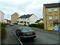
Sector Lane houses, Axminster
On the north side of Sector Lane, east of the Tigers Way junction. http://www.geograph.org.uk/photo/5306355
Image: © Jaggery
Taken: 9 Mar 2017
0.18 miles
7

Cridlake, Axminster
Cridlake is a cul-de-sac on the north side of Sector Lane.
Image: © Jaggery
Taken: 9 Mar 2017
0.18 miles
8
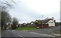
Junction of Halletts Way with Stony Lane, Axminster
Image: © David Smith
Taken: 30 Dec 2019
0.18 miles
9
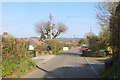
Sector Lane
Outer reaches of Axminster. The road later climbs steeply to the Dorset boundary in a greensand ridge.
Image: © Richard Webb
Taken: 8 Apr 2015
0.18 miles