IMAGES TAKEN NEAR TO
Dukes Way, AXMINSTER, EX13 5FN
Introduction
This page details the photographs taken nearby to Dukes Way, EX13 5FN by members of the Geograph project.
The Geograph project started in 2005 with the aim of publishing, organising and preserving representative images for every square kilometre of Great Britain, Ireland and the Isle of Man.

There are currently over 7.5m images from over14,400 individuals and you can help contribute to the project by visiting https://www.geograph.org.uk
Image Map
Images are licensed for reuse under creativecommons.org/licenses/by-sa/2.0
Notes
- Clicking on the map will re-center to the selected point.
- The higher the marker number, the further away the image location is from the centre of the postcode.
Image Listing (21 Images Found)
Images are licensed for reuse under creativecommons.org/licenses/by-sa/2.0
Image
Details
Distance
1

Public Footpath to Axminster
Route from Woodbury Lane towards Foxhill.
Image: © Peter Holmes
Taken: 14 Nov 2008
0.09 miles
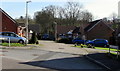
2

Two Bridges
Linking residential development at Woodbury Way with Public footpath. Contrast bridge constructions.
http://www.geograph.org.uk/photo/1070201
Image: © Peter Holmes
Taken: 14 Nov 2008
0.13 miles
3

Footbridge over tributary of River Axe
Public footpath to Woodbury Lane, contrast construction with that of adjacent bridge.
Image: © Peter Holmes
Taken: 14 Nov 2008
0.15 miles
4

Public footpath from Morton Way
Popular route for dog walkers.
Image: © Peter Holmes
Taken: 14 Nov 2008
0.18 miles
5
Phillips Court, Axminster
Cul-de-sac on the southeast side of Lyme Close.
Image: © Jaggery
Taken: 9 Mar 2017
0.19 miles
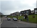
6

Bend in Lyme Close, Axminster
Ahead for Lea Combe and Fosseway Close. The Phillips Court junction is on the left.
Behind the camera for Axminster Fire Station https://www.geograph.org.uk/photo/5306661 and the B3261 Lyme Road.
Image: © Jaggery
Taken: 9 Mar 2017
0.20 miles
7
Long Ragg Court, Lyme Close, Axminster
Flats near Axminster Community Fire Station. http://www.geograph.org.uk/photo/5306661
Image: © Jaggery
Taken: 9 Mar 2017
0.21 miles
8

Lyme Close electricity substation, Axminster
The Western Power Distribution electricity substation, identifier 252454,
is behind locked wooden doors on the north side of Lyme Close.
Image: © Jaggery
Taken: 9 Mar 2017
0.21 miles
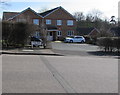
9
Wyke Road, Axminster
Part of a housing estate on the south of Axminster, built around an old road out of the town
Image: © David Smith
Taken: 30 Dec 2019
0.21 miles
10

Benchmark on #15 Hillhead Terrace, Musbury Road
Ordnance Survey cut mark benchmark described on the Bench Mark Database at http://www.bench-marks.org.uk/bm45531
Image: © Roger Templeman
Taken: 20 Sep 2012
0.22 miles