IMAGES TAKEN NEAR TO
Chard Road, AXMINSTER, EX13 5ED
Introduction
This page details the photographs taken nearby to Chard Road, EX13 5ED by members of the Geograph project.
The Geograph project started in 2005 with the aim of publishing, organising and preserving representative images for every square kilometre of Great Britain, Ireland and the Isle of Man.

There are currently over 7.5m images from over14,400 individuals and you can help contribute to the project by visiting https://www.geograph.org.uk
Image Map
Images are licensed for reuse under creativecommons.org/licenses/by-sa/2.0
Notes
- Clicking on the map will re-center to the selected point.
- The higher the marker number, the further away the image location is from the centre of the postcode.
Image Listing (69 Images Found)
Images are licensed for reuse under creativecommons.org/licenses/by-sa/2.0
Image
Details
Distance
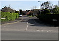
1
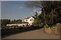
Victorian villa, Axminster
Brookhill is a detached villa set back from the Chard Road, and gradually becoming surrounded by modern housing developments.
Image: © Derek Harper
Taken: 25 May 2013
0.01 miles
2
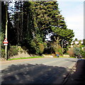
Down Chard Road, Axminster
The A358 Chard Road descends past a warning sign showing a skid risk for half a mile ahead.
Image: © Jaggery
Taken: 9 Mar 2017
0.02 miles
3

Latches Walk, Axminster
From Chard Road, Latches Walk leads to Latchmount Gardens.
Image: © Jaggery
Taken: 9 Mar 2017
0.06 miles
4
From Chard Street to Chard Road, Axminster
Near the Latches Walk junction on the right, a sign shows that Chard Street is on the left, Chard Road on the right. The street and road are part of the A358.
Image: © Jaggery
Taken: 9 Mar 2017
0.07 miles
5

Three nameboards facing Lyme Road, Axminster
On the left here https://www.geograph.org.uk/photo/6747272 viewed in March 2017. The boards show
The Axe Valley Community College & Sixth Form Centre
Leisure Centre Axminster
the flamingo pool
Image: © Jaggery
Taken: 9 Mar 2017
0.08 miles
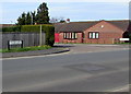
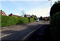
6

Millbrook Cross
The junction northeast of Axminster, seen from the A358 Chard Road. Being re-thatched is the C18 Millbrook Farm http://list.english-heritage.org.uk/resultsingle.aspx?uid=1333493&searchtype=mapsearch . Behind it is the new housing development at Millbrook Meadows.
Image: © Derek Harper
Taken: 25 May 2013
0.08 miles
8
Hilary Gardens, Axminster
Cul-de-sac on the southeast side of Chard Road.
Image: © Jaggery
Taken: 9 Mar 2017
0.10 miles
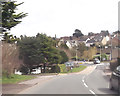
9

Mini-roundabout at junction of Chard Road and Stoney Lane
The bridge is over Mill Brook, and has been replaced since it hosted Ordnance Survey benchmarks, see http://www.bench-marks.org.uk/bm45441
Image: © Roger Templeman
Taken: 20 Sep 2012
0.10 miles
10
Hedges and houses, Hilary Gardens, Axminster
Cul-de-sac on the southeast side of Chard Road.
Image: © Jaggery
Taken: 9 Mar 2017
0.10 miles