IMAGES TAKEN NEAR TO
Heavitree Road, EXETER, EX1 2LX
Introduction
This page details the photographs taken nearby to Heavitree Road, EX1 2LX by members of the Geograph project.
The Geograph project started in 2005 with the aim of publishing, organising and preserving representative images for every square kilometre of Great Britain, Ireland and the Isle of Man.

There are currently over 7.5m images from over14,400 individuals and you can help contribute to the project by visiting https://www.geograph.org.uk
Image Map
Images are licensed for reuse under creativecommons.org/licenses/by-sa/2.0
Notes
- Clicking on the map will re-center to the selected point.
- The higher the marker number, the further away the image location is from the centre of the postcode.
Image Listing (287 Images Found)
Images are licensed for reuse under creativecommons.org/licenses/by-sa/2.0
Image
Details
Distance
1
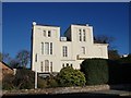
Building on Heavitree Road, Exeter
At the corner of Grendon Road, this building houses several offices and a day nursery.
Image: © Derek Harper
Taken: 25 Nov 2008
0.01 miles
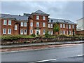
2
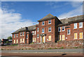
Contrasting buildings, Heavitree Road, Exeter
The red brick former hospital building contrasts with the starkness of its neighbour
Image: © David Smith
Taken: 12 Jul 2020
0.01 miles
3
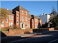
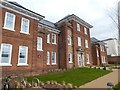
Hospital building, Heavitree Road, Exeter
The building is part of the Royal Devon and Exeter NHS Foundation Trust Hospital, and forms part of the Peninsula Postgraduate Health Institute, providing a Clinical Skills Resource Centre.
Image: © Derek Harper
Taken: 25 Nov 2008
0.02 miles
4

Almshouses in Grendon Road, Exeter
The end of a row of neo-Tudor almshouses built in 1880.
Image: © Derek Harper
Taken: 1 Nov 2006
0.02 miles

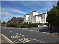
6
Atlas House - Student Accommodation in Exeter
Image: © Fernweh
Taken: 2 Oct 2021
0.03 miles
7
Boarded Up Hospital
The same building as in this shot from 2008 when it was still in use. Image
Now closed and boarded up and awaiting its fate.
Image: © Des Blenkinsopp
Taken: 22 Aug 2016
0.03 miles
8
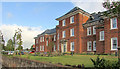
Former hospital building, Heavitree Road, Exeter
This is now student accommodation. The circular plaque reads: 1914-1919 This building was used as Exeter Temporary War Hospital No 3 for the treatment of sick and wounded soldiers in the First World War Devon County Council
Image: © David Smith
Taken: 16 Mar 2019
0.03 miles
9
Atlas house, Exeter
Shown in its former guise as a hospital building and during closure at http://www.geograph.org.uk/gridref/SX9392?centi=SX932926 . Now student accommodation; a new building has risen beside it - see Image
Image: © Derek Harper
Taken: 28 Sep 2019
0.03 miles
10
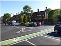
Part of Waitrose supermarket car park, Exeter
The car park has been fitted between existing buildings and the store itself. This section backs onto the almshouses in Grendon Road Image
Image: © David Smith
Taken: 10 Oct 2014
0.03 miles