IMAGES TAKEN NEAR TO
Clifton Hill, EXETER, EX1 2EL
Introduction
This page details the photographs taken nearby to Clifton Hill, EX1 2EL by members of the Geograph project.
The Geograph project started in 2005 with the aim of publishing, organising and preserving representative images for every square kilometre of Great Britain, Ireland and the Isle of Man.

There are currently over 7.5m images from over14,400 individuals and you can help contribute to the project by visiting https://www.geograph.org.uk
Image Map
Images are licensed for reuse under creativecommons.org/licenses/by-sa/2.0
Notes
- Clicking on the map will re-center to the selected point.
- The higher the marker number, the further away the image location is from the centre of the postcode.
Image Listing (201 Images Found)
Images are licensed for reuse under creativecommons.org/licenses/by-sa/2.0
Image
Details
Distance
1
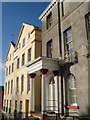
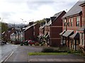
Houses in Clifton Hill, Exeter
An impressive Victorian town house, with striking Corinthian columns in its porch, set next to what looks like a modern build, one that fits in fairly well.
Image: © Derek Harper
Taken: 6 Dec 2006
0.01 miles
2
Houses on Clifton Hill, Exeter
A view up the hill past Victorian and modern buildings, including the houses seen in Image
Image: © Derek Harper
Taken: 6 Dec 2006
0.01 miles
3
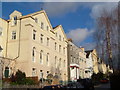
5-12 Clifton Hill, Exeter
A typically variegated collection of early Victorian villas evidencing the shift from Georgian uniformity. Grade II listed.
Image: © Stephen Richards
Taken: 19 Jun 2014
0.01 miles
4

Clifton Hill
Still climbing up from the Exe valley in this part of town.
Image: © Des Blenkinsopp
Taken: 22 Aug 2016
0.03 miles
5

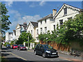
Clifton Hill Exeter
A terrace of houses dating from the early 19th century
Image: © David Smith
Taken: 15 Dec 2010
0.04 miles
6
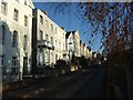
Clifton Hill Exeter
A terrace of houses which mostly date from the early 19th century, with some grand porticos. The houses face the road, and have gardens on the other side of the road.
Image: © David Smith
Taken: 15 Dec 2010
0.04 miles
7
Jesmond Road, Exeter
Modern semis, then an inter-war terrace, and in the distance the United Reformed church spire and the cathedral towers, plus the cranes at the Princesshay redevelopment. Bit of a blockage at the bottom of the road. Taken from Polsloe Road.
Image: © Derek Harper
Taken: 13 Nov 2006
0.04 miles
8
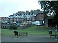
Belmont Park and Gordon Road, Exeter
The table-tennis player was in the process of recovering his dropped bat.
Image: © David Smith
Taken: 16 Aug 2020
0.05 miles
9
Belmont Park and Jesmond Road, Exeter
At the top of Gordon Road, which runs beside the park, steps lead down into Jesmond Road, this section of which is little more than a back alley, although that does not prevent cars from speeding along it.
Image: © Derek Harper
Taken: 6 Dec 2006
0.05 miles
10
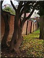
Leaning wall, Belmont Park
This wall is at the south-east corner of the park, where it borders Jesmond Road; see also Image
Image: © Derek Harper
Taken: 17 Nov 2008
0.05 miles