IMAGES TAKEN NEAR TO
Axmouth, SEATON, EX12 4BJ
Introduction
This page details the photographs taken nearby to EX12 4BJ by members of the Geograph project.
The Geograph project started in 2005 with the aim of publishing, organising and preserving representative images for every square kilometre of Great Britain, Ireland and the Isle of Man.

There are currently over 7.5m images from over14,400 individuals and you can help contribute to the project by visiting https://www.geograph.org.uk
Image Map
Images are licensed for reuse under creativecommons.org/licenses/by-sa/2.0
Notes
- Clicking on the map will re-center to the selected point.
- The higher the marker number, the further away the image location is from the centre of the postcode.
Image Listing (3 Images Found)
Images are licensed for reuse under creativecommons.org/licenses/by-sa/2.0
Image
Details
Distance
1
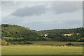
Stedcombe House
Seen from the Seaton Tramway (with a long-ish lens). It was built by Richard Hallett about 1697, in the latest William & Mary style, funded at least in part from the profits of the slave trade. The previous house was razed by Royalists during the Civil War. ( http://www.lymeregismuseum.co.uk/ethnic_Minorities_3.htm , http://www.bbc.co.uk/dorset/content/articles/2004/10/21/lyme_history_feature.shtml , http://www.thelocalchannel.co.uk/Axmouth/home.aspx )
The house fell vacant in the 1960s, became derelict by the 1970s, but was restored by 1992. ( http://www.rgspiller.co.uk/printfriendlyprojects.cfm?CFID=3398689&CFTOKEN=86470169&id=111 )
Image: © Katy Walters
Taken: 19 Sep 2007
0.08 miles
2
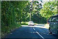
B3172 towards Axmouth and Seaton
Passing the way to Stedcombe Farm on the left.
Image: © Robin Webster
Taken: 20 Jul 2019
0.15 miles
3
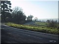
Frosty corner under Hawkesdown Hill
Image: © Sarah Charlesworth
Taken: 7 Dec 2008
0.18 miles