IMAGES TAKEN NEAR TO
Stepps Lane, SEATON, EX12 4AR
Introduction
This page details the photographs taken nearby to Stepps Lane, EX12 4AR by members of the Geograph project.
The Geograph project started in 2005 with the aim of publishing, organising and preserving representative images for every square kilometre of Great Britain, Ireland and the Isle of Man.

There are currently over 7.5m images from over14,400 individuals and you can help contribute to the project by visiting https://www.geograph.org.uk
Image Map
Images are licensed for reuse under creativecommons.org/licenses/by-sa/2.0
Notes
- Clicking on the map will re-center to the selected point.
- The higher the marker number, the further away the image location is from the centre of the postcode.
Image Listing (42 Images Found)
Images are licensed for reuse under creativecommons.org/licenses/by-sa/2.0
Image
Details
Distance
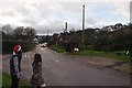
1

Axmouth : Stepps Lane
Two people walking hand in hand as they support each other up the steep hill.
Image: © Lewis Clarke
Taken: 21 Dec 2011
0.01 miles
2
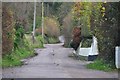
Axmouth : Stepps Lane
Stepps Lane keeps on going up to the top of the hill.
Image: © Lewis Clarke
Taken: 21 Dec 2011
0.04 miles
3
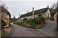
Axmouth : Stepps Lane
Stepps Lane heading up a steep hill with cottages on either side the road.
Image: © Lewis Clarke
Taken: 21 Dec 2011
0.05 miles
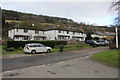
4
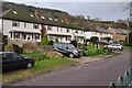
Axmouth : Southcoombe Terrace
Southcoombe Terrace and houses in Axmouth.
Image: © Lewis Clarke
Taken: 21 Dec 2011
0.06 miles
5
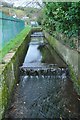
Axmouth : Small Stream
A small stream runs through Axmouth by Chapel Street.
Image: © Lewis Clarke
Taken: 21 Dec 2011
0.06 miles
6

Axmouth : Stepps Lane
Stepps Lane with some construction work going on here at this house.
Image: © Lewis Clarke
Taken: 21 Dec 2011
0.06 miles
7
Axmouth : Chapel Street
Looking back toward Chapel Street from Southcoombe Terrace with Stepps Lane on the left.
Image: © Lewis Clarke
Taken: 21 Dec 2011
0.07 miles
8
Houses in Axmouth
These Terraced houses which look like they may be ex-social housing are in Chapel St opposite the end of Steps Lane. behind them is Hawkesdown Hill which has an iron Age hill Fort on top of it.
Image: © Nigel Mykura
Taken: 21 Jan 2018
0.07 miles
9

Axmouth : Chapel Street Bus Shelter
A bus stop on Chapel Street in Axmouth.
Image: © Lewis Clarke
Taken: 21 Dec 2011
0.07 miles
10
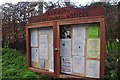
Axmouth : Axmouth Parish Council Notices
A noticeboard with all the things the council wants us to know.
Image: © Lewis Clarke
Taken: 21 Dec 2011
0.08 miles