1
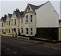
East side of Beach Road, Seaton
Redcliffs B&B is on the left.
Image: © Jaggery
Taken: 20 May 2018
0.01 miles
2
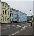
Beach Road - Harbour Road
Image: © Betty Longbottom
Taken: 14 May 2018
0.01 miles
3
Beach Road runs down to Harbour Road
Image: © Steve Daniels
Taken: 27 May 2016
0.01 miles
4
Zebra crossing, Harbour Road, Seaton
Across the B3172 Harbour Road viewed from the corner of Beach Road. Although Belisha beacons had marked pedestrian crossings in the UK from 1934, it was not until 1951 that the now familiar black and white stripes stretching across the width of the road were officially introduced. Previously, there were only metal studs across the road surface.
Image: © Jaggery
Taken: 20 May 2018
0.02 miles
5
Mansion House 1806 blue plaque, Beach Road, Seaton
Located on the wall behind the white car here. https://www.geograph.org.uk/photo/6039173
Image: © Jaggery
Taken: 20 May 2018
0.02 miles
6
B3172 Harbour Road, Seaton
Kings Court bus stop, westbound, is on the left.
Image: © Robin Webster
Taken: 20 Jul 2019
0.02 miles
7
Large sign and small sign, Harbour Road, Seaton
Facing westbound traffic on the B3172 Harbour Road on the approach to a roundabout.
The larger sign shows the road for through traffic and a car park & coach/bus park.
The much smaller sign shows the number 52 next to a depiction of a bicycle, which indicates National Cycle Network Route 52. This appears to be an error because route 52 is in the English Midlands whereas Seaton in East Devon is on the south coast of England. It looks like this is Route 2, a long distance cycle route which, when complete, will link Dover in Kent with St Austell in Cornwall via the south coast of England.
Image: © Jaggery
Taken: 20 May 2018
0.02 miles
8
Curium Court
Block of 8 flats which planning applications suggest was built in the 1980s.
Image: © Ian Capper
Taken: 8 Feb 2020
0.02 miles
9
Beach Road, Seaton
The building to the left is called White Cliff and was formerly a hotel. The Beach Hotel. It was originally a rather grand private house called the Mansion House built in 1806.
Image: © Anthony Vosper
Taken: 26 Jul 2013
0.02 miles
10
Three-storey building, Beach Road, Seaton
The blue plaque https://www.geograph.org.uk/photo/6039177 on the building records that this was the Mansion House built in 1806.
The house then became the Beach Hotel with assembly rooms added in 1892.
The name later changed to White Cliff.
Image: © Jaggery
Taken: 20 May 2018
0.02 miles


