IMAGES TAKEN NEAR TO
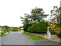
Durley Road, SEATON, EX12 2HW
Introduction
This page details the photographs taken nearby to Durley Road, EX12 2HW by members of the Geograph project.
The Geograph project started in 2005 with the aim of publishing, organising and preserving representative images for every square kilometre of Great Britain, Ireland and the Isle of Man.

There are currently over 7.5m images from over14,400 individuals and you can help contribute to the project by visiting https://www.geograph.org.uk
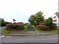
Image Map
Images are licensed for reuse under creativecommons.org/licenses/by-sa/2.0
Notes
- Clicking on the map will re-center to the selected point.
- The higher the marker number, the further away the image location is from the centre of the postcode.
Image Listing (32 Images Found)
Images are licensed for reuse under creativecommons.org/licenses/by-sa/2.0
Image
Details
Distance
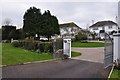
1
Channel to Channel (5)
This is a bend on Durley Road.
Image: © Shazz
Taken: 14 Sep 2014
0.09 miles
2
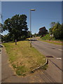
Channel to Channel (4)
The route turns left into Durley Road.
Image: © Shazz
Taken: 14 Sep 2014
0.11 miles
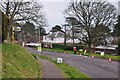
3
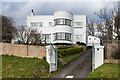
Casablanca
c1930s house on Beer Road, previously named Claireaves.
Image: © Ian Capper
Taken: 8 Feb 2020
0.15 miles
4
Beer Road
Houses on Beer Road. In the centre of the photo is Casablanca - see Image
Image: © Ian Capper
Taken: 8 Feb 2020
0.15 miles
5

Beer Road
Two houses under construction on Beer Road.
Image: © Ian Capper
Taken: 8 Feb 2020
0.17 miles
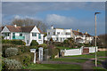
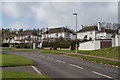
6
Seaton : Houses on Beer Road
Housing on Beer Road which overlooks the coast and Seaton seafront down the hill.
Image: © Lewis Clarke
Taken: 10 Mar 2013
0.18 miles
7
Seaton : Beer Road
Beer Road between Seaton and Beer in East Devon.
Image: © Lewis Clarke
Taken: 10 Mar 2013
0.18 miles
9
Seaton : Beer Road
Beer Road heading down the hillside and into the town.
Image: © Lewis Clarke
Taken: 10 Mar 2013
0.19 miles
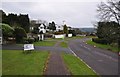
10
Beer Road and Old Beer Road
The old road is to the left; the visible section is a footpath. The B3174 now follows a route that turns inland, while the old road drops to Seaton Hole, carrying the inland route of the South West Coast Path.
Image: © Derek Harper
Taken: 19 Jun 2012
0.20 miles