IMAGES TAKEN NEAR TO
Ryalls Court, SEATON, EX12 2HJ
Introduction
This page details the photographs taken nearby to Ryalls Court, EX12 2HJ by members of the Geograph project.
The Geograph project started in 2005 with the aim of publishing, organising and preserving representative images for every square kilometre of Great Britain, Ireland and the Isle of Man.

There are currently over 7.5m images from over14,400 individuals and you can help contribute to the project by visiting https://www.geograph.org.uk
Image Map
Images are licensed for reuse under creativecommons.org/licenses/by-sa/2.0
Notes
- Clicking on the map will re-center to the selected point.
- The higher the marker number, the further away the image location is from the centre of the postcode.
Image Listing (89 Images Found)
Images are licensed for reuse under creativecommons.org/licenses/by-sa/2.0
Image
Details
Distance
1
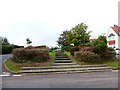
Channel to Channel (4)
The route turns left into Durley Road.
Image: © Shazz
Taken: 14 Sep 2014
0.11 miles
2
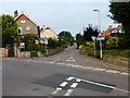
Channel to Channel (2)
Here the walk crosses Beer Road.
Image: © Shazz
Taken: 14 Sep 2014
0.12 miles
3
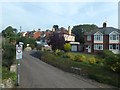
Marlpit Lane, Seaton
No longer a lane, no longer leading to a marlpit, this is now a residential road on the edge of Seaton
Image: © David Smith
Taken: 11 Aug 2012
0.12 miles
4

Channel to Channel (3)
Here's a look back down Marlpit Lane.
Image: © Shazz
Taken: 14 Sep 2014
0.13 miles
5
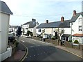
Queen Street, Seaton
A street of mixed older houses about 400 metres from the sea front
Image: © David Smith
Taken: 11 Aug 2012
0.14 miles

7

The Beer Road`
At the western end of the Seaton seafront , the Beer Rd roises up and it passes the end of this road, Wessiters.
Image: © Nigel Mykura
Taken: 21 Jan 2018
0.17 miles
8
Belmont House
Town house built around 1840, originally called Rose Cottage. For many years it was used by a housing agency, before being converted to residential use in aorudn 2013. Grade II listed - see www.historicengland.org.uk/listing/the-list/list-entry/1317652.
Image: © Ian Capper
Taken: 8 Feb 2020
0.18 miles

10

Seafield Road
Terrace on Seafield Road, much of which is shown on the 1889 1:2,500 map, with the exception of the right hand section which first appears on the 1904 edition. On both maps it is marked as Seaview Crescent, the current name not appearing until the 1936 edition, prior to which it was applied to what is now Sea Hill. Viewed across the bowling green in Seafield and Festival Gardens.
Image: © Ian Capper
Taken: 8 Feb 2020
0.18 miles