IMAGES TAKEN NEAR TO
Higher Broad Oak Road, OTTERY ST. MARY, EX11 1XF
Introduction
This page details the photographs taken nearby to Higher Broad Oak Road, EX11 1XF by members of the Geograph project.
The Geograph project started in 2005 with the aim of publishing, organising and preserving representative images for every square kilometre of Great Britain, Ireland and the Isle of Man.

There are currently over 7.5m images from over14,400 individuals and you can help contribute to the project by visiting https://www.geograph.org.uk
Image Map (Loading...)


Getting Data...Please wait
Leaflet Map data © OpenStreetMap
Images are licensed for reuse under creativecommons.org/licenses/by-sa/2.0
Notes
- Clicking on the map will re-center to the selected point.
- The higher the marker number, the further away the image location is from the centre of the postcode.
Image Listing (11 Images Found)
Images are licensed for reuse under creativecommons.org/licenses/by-sa/2.0
Image
Details
Distance
1
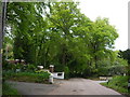
Higher Broad Oak Road
The houses in this area tend to be occupied by those considered in the higher echelons of society as indicated by the flagpoles with union jacks on the front lawn. White Farm Lane on the left proudly announces with its sign that it is a private road.
Image: © Nigel Mykura
Taken: 13 May 2016
0.03 miles
2

Ford Lane,Broad Oak Bottom
A small stream runs behind the bungalow.
Image: © Anthony Vosper
Taken: 1 Feb 2014
0.03 miles

4
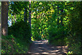
West Hill : Hawkins Lane
Looking along Hawkins Lane in West Hill.
Image: © Lewis Clarke
Taken: 13 May 2018
0.06 miles
5
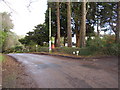
Community postbox, West Hill
The area describes itself as a Woodland community.
Image: © Anthony Vosper
Taken: 1 Feb 2014
0.06 miles


8

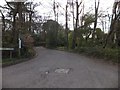
Lower Broad Oak Road, West Hill
Leafy suburbia in the midst of rural Devon. Seen from the junction with Ford Lane.
Image: © Derek Harper
Taken: 3 May 2006
0.16 miles
9
Ford Lane in West Hill
The lane joins Lower Broad Oak Road close to a bridge over a small stream, which (presumably) was once forded giving rise to the name Ford Lane.
Image: © David Smith
Taken: 15 Apr 2012
0.20 miles
