IMAGES TAKEN NEAR TO
Mill Street, OTTERY ST. MARY, EX11 1AH
Introduction
This page details the photographs taken nearby to Mill Street, EX11 1AH by members of the Geograph project.
The Geograph project started in 2005 with the aim of publishing, organising and preserving representative images for every square kilometre of Great Britain, Ireland and the Isle of Man.

There are currently over 7.5m images from over14,400 individuals and you can help contribute to the project by visiting https://www.geograph.org.uk
Image Map (Loading...)


Getting Data...Please wait
Leaflet Map data © OpenStreetMap
Images are licensed for reuse under creativecommons.org/licenses/by-sa/2.0
Notes
- Clicking on the map will re-center to the selected point.
- The higher the marker number, the further away the image location is from the centre of the postcode.
Image Listing (139 Images Found)
Images are licensed for reuse under creativecommons.org/licenses/by-sa/2.0
Image
Details
Distance
1
Orange Way in Devon and Torbay (374)
The footpath goes down to the river north of the B3174 at Ottery St Mary.
Image: © Shazz
Taken: 16 Apr 2012
0.01 miles
2
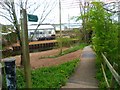
The Old Station
With tracks long gone all that remains of Ottery St Mary's station is the yellow building. The offices to the right belong to the Social services.
Not in the picture is the R.I.O centre, Recycling in Ottery,here you can literally find anything from the kitchen sink to a set of weights.
Image: © Anthony Vosper
Taken: 5 Oct 2009
0.02 miles
3
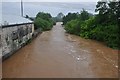
Ottery St Mary : The River Otter
An unusually high River Otter after a night of heavy rain.
Image: © Lewis Clarke
Taken: 7 Jul 2012
0.02 miles
4
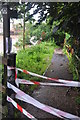
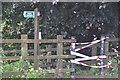
Ottery St Mary : Closed Public Footpath
The Fire & Rescue Service have closed this footpath heading up to Mill Leat due to flooding.
Image: © Lewis Clarke
Taken: 7 Jul 2012
0.03 miles
5
Inscription on iron bridge over River Otter
Image: © David Smith
Taken: 18 Apr 2011
0.04 miles
6
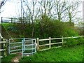
Ottery St Mary : Closed Public Footpath
The fire service have shut off this footpath with some tape due to flooding.
Image: © Lewis Clarke
Taken: 7 Jul 2012
0.04 miles
7
Orange Way in Devon and Torbay (373)
Steps lead up to the B3174 by the river at Ottery St Mary.
Image: © Shazz
Taken: 16 Apr 2012
0.04 miles
8
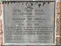
Plaque on St Saviours Bridge, Ottery St Mary
All you need to know.
Image: © Chris Allen
Taken: 8 Aug 2009
0.04 miles
9
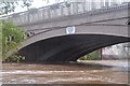
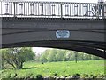
Ottery St Mary : St Saviours Bridge & River Otter
Road bridge over River Otter. Dated 1851. Single-span bridge of 23m. Comprising five segmental arch cast-iron girders set side-by-side and splayed volcanic ashlar abutments with granite coping, a bull-nose string at road level and terminal piers. The segmental arch girders have pierced spandrels with Gothic arcading, panels in frieze above with cusped ends, quatrefoils over and cast-iron parapet railings with small cusped arches. At the top of the arch a small cast-iron plaque inscribed :-'Joseph Butler and Co. Stanningley Iron Works Nr Leeds 1851'.
Image: © Lewis Clarke
Taken: 7 Jul 2012
0.04 miles
10
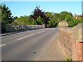
St Saviour's Bridge, Ottery St Mary
The bridge over the River Otter is described at http://list.english-heritage.org.uk/resultsingle.aspx?uid=1389504&searchtype=mapsearch .
Image: © Derek Harper
Taken: 2 Jun 2006
0.04 miles