IMAGES TAKEN NEAR TO
Hawthorn Drive, SIDMOUTH, EX10 9XW
Introduction
This page details the photographs taken nearby to Hawthorn Drive, EX10 9XW by members of the Geograph project.
The Geograph project started in 2005 with the aim of publishing, organising and preserving representative images for every square kilometre of Great Britain, Ireland and the Isle of Man.

There are currently over 7.5m images from over14,400 individuals and you can help contribute to the project by visiting https://www.geograph.org.uk
Image Map
Images are licensed for reuse under creativecommons.org/licenses/by-sa/2.0
Notes
- Clicking on the map will re-center to the selected point.
- The higher the marker number, the further away the image location is from the centre of the postcode.
Image Listing (50 Images Found)
Images are licensed for reuse under creativecommons.org/licenses/by-sa/2.0
Image
Details
Distance
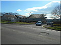
1
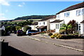
Houses on Ladymead
Ladymead is on the housing estate on the very northwestern edge of Sidmouth close to the A3052.
Image: © Nigel Mykura
Taken: 23 Sep 2022
0.05 miles
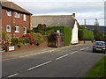
2
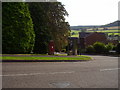
Stowford rise junction with Hawthorn close.
A Post box and telephone box serve the local community.
Image: © Anthony Vosper
Taken: 17 Sep 2009
0.06 miles
3
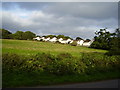
Soon to be built on
Woolbrook Road looking towards Ladymead. Green pastures await affordable housing on the edge of town.
Image: © Anthony Vosper
Taken: 2 Oct 2009
0.07 miles
4
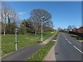
Why stop here?
The end of a cycle lane in Stowford Rise; doubtless many cyclists ignore the sign and continue along the path
Image: © David Smith
Taken: 4 Apr 2014
0.07 miles
5
Bus Shelter, Woolbrook Road
Modern tiles and thatch keep each other company next to the town bound bus stop.
Image: © Anthony Vosper
Taken: 2 Oct 2009
0.09 miles
6
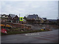
The infilling begins
Part of a new housing project on Woolbrook Road.The brook is now in a culvert below the 30 mph sign.
Image: © Anthony Vosper
Taken: 24 Jan 2011
0.09 miles
7
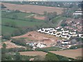
Building site, Higher Woolbrook
View from Bulverton Hill.
Image: © Richard Webb
Taken: 19 Apr 2011
0.09 miles
8
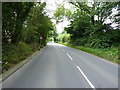
A3052 towards Stowford
On the main drag west from Lyme Regis to Exeter.
Image: © Richard Law
Taken: 15 Jul 2017
0.09 miles
9

Sidmouth floods (7)
A drive way in Higher Woolbrook turns in to a muddy stream as water runs off a nearby field.
Image: © Anthony Vosper
Taken: 7 Jul 2012
0.12 miles
10
A work in progress
Extension work being carried out on the Beacon Health Centre.
Sedemunda Close.
Image: © Anthony Vosper
Taken: 28 Feb 2023
0.13 miles