IMAGES TAKEN NEAR TO
Woolbrook Road, SIDMOUTH, EX10 9UU
Introduction
This page details the photographs taken nearby to Woolbrook Road, EX10 9UU by members of the Geograph project.
The Geograph project started in 2005 with the aim of publishing, organising and preserving representative images for every square kilometre of Great Britain, Ireland and the Isle of Man.

There are currently over 7.5m images from over14,400 individuals and you can help contribute to the project by visiting https://www.geograph.org.uk
Image Map
Images are licensed for reuse under creativecommons.org/licenses/by-sa/2.0
Notes
- Clicking on the map will re-center to the selected point.
- The higher the marker number, the further away the image location is from the centre of the postcode.
Image Listing (77 Images Found)
Images are licensed for reuse under creativecommons.org/licenses/by-sa/2.0
Image
Details
Distance
1
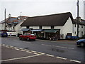
Woolbrook shops
Consisting of the newsagents and the local butcher.Anyone for a cooked chicken?
Image: © Anthony Vosper
Taken: 23 Sep 2009
0.01 miles
2

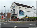
All change again in Woolbrook
The white building is now primarily the Jurassic Veterinary Practice.
The Post Office now only has a small counter.
The petrol station has changed hands from Jet to Harvest.
Compare this with Image
Image: © Anthony Vosper
Taken: 4 Jul 2016
0.01 miles
3
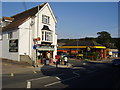
Woolbrook Post Office Stores, Sidmouth
Located at 12 Woolbrook Road. A fire station and ambulance station are on the left. http://www.geograph.org.uk/photo/3517888
Image: © Jaggery
Taken: 18 Jun 2013
0.01 miles
4
Woolbrook, Post office
The buttress above the Post box is all that remains of the bus depot that stood on the next door car park site.
Image: © Anthony Vosper
Taken: 16 Sep 2009
0.01 miles
5

Lower Woolbrook farmhouse
A late 17th or early 18th Century farmhouse, given a Grade II listing https://www.britishlistedbuildings.co.uk/101228410-lower-woolbrook-farmhouse-sidmouth#.WYrxnlV96M8 in 1973. All its surrounding lands have long since been given over to housing and urban development.
Image: © Richard Law
Taken: 19 Jul 2017
0.03 miles
6
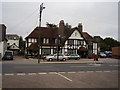
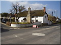
The Balfour Arms Woolbrook.
1930's pub. Built to serve the neighbouring estate.
Image: © Anthony Vosper
Taken: 8 Sep 2009
0.03 miles
7
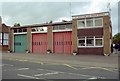
Sidmouth Fire Station and Ambulance Station
Sidmouth Fire Station and Ambulance Station, Woolbrook Road, Sidmouth, Devon. The building all belongs to the fire service, but the left hand bay with the green doors is 'loaned' to the ambulance service.
Image: © Kevin Hale
Taken: 6 Oct 2001
0.03 miles
8
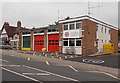
Sidmouth Fire Station and Ambulance Station
A green and yellow door for the ambulance station, twin red doors for the fire station
which is part of Devon & Somerset Fire & Rescue Service.
The location is Woolbrook Road, next door to The Balfour http://www.geograph.org.uk/photo/3517807 on the left.
Here's http://www.geograph.org.uk/photo/67987 a view of the two stations taken in 2001.
Image: © Jaggery
Taken: 18 Jun 2013
0.03 miles
9
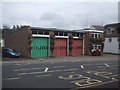
Sidmouth Fire and Ambulance Station
Image: © Sarah Charlesworth
Taken: 14 Oct 2008
0.03 miles
10
Lower Woolbrook farmhouse
A 17/18 century farmhouse. now a private home on the edge of the community.
Image: © Anthony Vosper
Taken: 7 Mar 2011
0.03 miles