IMAGES TAKEN NEAR TO
Woolbrook Meadows, SIDMOUTH, EX10 9UH
Introduction
This page details the photographs taken nearby to Woolbrook Meadows, EX10 9UH by members of the Geograph project.
The Geograph project started in 2005 with the aim of publishing, organising and preserving representative images for every square kilometre of Great Britain, Ireland and the Isle of Man.

There are currently over 7.5m images from over14,400 individuals and you can help contribute to the project by visiting https://www.geograph.org.uk
Image Map
Images are licensed for reuse under creativecommons.org/licenses/by-sa/2.0
Notes
- Clicking on the map will re-center to the selected point.
- The higher the marker number, the further away the image location is from the centre of the postcode.
Image Listing (69 Images Found)
Images are licensed for reuse under creativecommons.org/licenses/by-sa/2.0
Image
Details
Distance
1
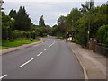
Bus stops Woolbrook road.
The main bus route in and out of town. You have a choice, sit and wait or stand and shelter but not both.
Image: © Anthony Vosper
Taken: 31 Aug 2009
0.06 miles
2

Footpath Core Hill Road
Local footpath No15. Quite a bit of this area can still be traversed by using the original footpaths through the area.
Image: © Anthony Vosper
Taken: 3 Sep 2009
0.06 miles
3

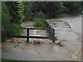
Sidmouth floods (2)
Water cascades down Woolbrook Road after torrential overnight rain.
The water is actually subsiding, this photograph was taken at 7.30 in the morning the peak flow was at 5.00 am.
Image: © Anthony Vosper
Taken: 7 Jul 2012
0.08 miles
4

More of the same
Woolbrook Road.
Early morning in November.
Fortunately an event that does not happen too often.
Image was one of the last events in 2016.
Image: © Anthony Vosper
Taken: 21 Nov 2016
0.08 miles
5

Sidmouth floods (1)
Woolbrook Road junction with Bennetts Hill.Torrential rain has caused the Woolbrook to burst its banks half a mile up the road.
This photograph was taken 7.30 in the morning as the water was subsiding it peaked about 5.30am.
The brook is normally 2 foot lower behind the fence on the right.
Image: © Anthony Vosper
Taken: 7 Jul 2012
0.09 miles
6
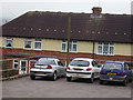
Manstone Ave Vent Pipe ( west)
Another of the towns sewage vent pipes. Situated at the top part of a 1920's council estate.
Image: © Anthony Vosper
Taken: 8 Sep 2009
0.10 miles
7
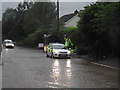
Sidmouth floods (3)
Woolbrook Road 7.30 in the morning, emergency services are at full stretch across East Devon as the county experiences its worst rain in 16 years.
Despite this our friendly police officer managed a wave.
Image: © Anthony Vosper
Taken: 7 Jul 2012
0.10 miles
8
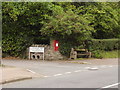
Woolbrook Rise Post box and ?
There is a danger of death warning on the site here. The electricity transformer however was never installed.
Image: © Anthony Vosper
Taken: 8 Sep 2009
0.10 miles
9
Sidmouth floods (4)
7.30 in the morning and the Woolbrook which is normally 2ft lower is actually going down; it peaked about 5am. A companion to the brick seen in the image was found in the middle of the road.
Image: © Anthony Vosper
Taken: 7 Jul 2012
0.10 miles
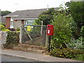
10
Ice House lane Post Box.
Situated next to the Woolbrook, just behind the wall and hedge. The two pipes are set so as to enable surplus water from the road to drain into the brook.
Image: © Anthony Vosper
Taken: 31 Aug 2009
0.11 miles