IMAGES TAKEN NEAR TO
Byes Lane, SIDMOUTH, EX10 9QU
Introduction
This page details the photographs taken nearby to Byes Lane, EX10 9QU by members of the Geograph project.
The Geograph project started in 2005 with the aim of publishing, organising and preserving representative images for every square kilometre of Great Britain, Ireland and the Isle of Man.

There are currently over 7.5m images from over14,400 individuals and you can help contribute to the project by visiting https://www.geograph.org.uk
Image Map
Images are licensed for reuse under creativecommons.org/licenses/by-sa/2.0
Notes
- Clicking on the map will re-center to the selected point.
- The higher the marker number, the further away the image location is from the centre of the postcode.
Image Listing (125 Images Found)
Images are licensed for reuse under creativecommons.org/licenses/by-sa/2.0
Image
Details
Distance
1
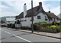
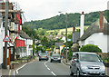
Farmhouse Cottage B&B, Sidford
Bed and breakfast accommodation in a thatched former farmhouse in Church Street.
Image: © Jaggery
Taken: 18 Jun 2013
0.01 miles
2
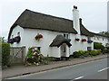
Warren Farmhouse, Church Street
The original farmhouse of the area, after which the modern housing developments in Image will have been named when they were built on its land. The house was given a Grade II listing https://www.britishlistedbuildings.co.uk/101333809-warrens-farmhouse-sidmouth#.WXtY9tQrLGg in 1973, and dates from the 18th Century.
Image: © Richard Law
Taken: 15 Jul 2017
0.01 miles
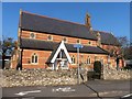
4
St Peter's church Sidford viewed from the west
Viewed across Church Street. Built in the 1860s as a chapel of ease, the Church of St Peter is the largest building in the village. It is in the Church of England diocese of Exeter.
Image: © Jaggery
Taken: 18 Jun 2013
0.03 miles
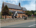
6
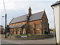
The Church of St Peter at Sidford
Viewed from the south-east.
Image: © Peter Wood
Taken: 2 Apr 2014
0.04 miles
7

Old Milestone by the A3052, Church Street, Sidford
Stone post (plate lost) by the A3052, in parish of SIDMOUTH (EAST DEVON District), Church Street, Sidford Village, by Milestone Cottage, East of cul de sac, in pavement beside door, on North side of road. Lyme iron plate, erected by the Lyme Regis (Charmouth to Wimple) turnpike trust in the 19th century.
See also https://www.flickr.com/photos/tollhouses/5600825652
Inscription once read:-
(Lyme Regis 14)
(Exeter 14)
Devon & Dartmoor HER listed. HER Number: MDV76438
https://www.heritagegateway.org.uk/Gateway/Results_Single.aspx?uid=MDV76438&resourceID=104
Milestone Society National ID: DV_EXLR14.
Image: © Alan Rosevear
Taken: 7 Apr 2011
0.04 miles
8
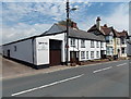
Northcott Bros Sidford
The long single-storey building on the left is the premises of Northcott Bros,
(established 1893), carpenters and funeral & cremation directors.
Image: © Jaggery
Taken: 18 Jun 2013
0.04 miles
9
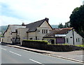
The Salty Monk, Sidford
Restaurant with B&B rooms available, located in Church Street on the corner of Packhorse Close.
Their website states that the name The Salty Monk is rooted in local history, and the fact that although the hotel is in Sidford, it is actually the last house in the parish of Salcombe Regis. Salcombe means Salty Vale in old English and is linked with King Athelstan who landed at Seaton. He made camp at Sidbury Castle and in 925 he gave Salcombe along with Sidbury, Branscombe and 23 other royal manors to Exeter Cathedral. The monks at the Benedictine monastery of St Peter in Exeter had to eat fish twice a week but in order to transport the fish it needed to be salted, so a salt works was set up on the beach. The original Salty Monk building here dates from the 16th century.
Image: © Jaggery
Taken: 18 Jun 2013
0.04 miles
10

St. Peter's Church, Sidford, Devon
Substantial Victorian church, but lacking tower or spire. This is on the north side of the A3052, just west of the bridge over the River Sid.
Image: © Dr Neil Clifton
Taken: 30 Mar 2009
0.04 miles