IMAGES TAKEN NEAR TO
Woolbrook Park, SIDMOUTH, EX10 9DX
Introduction
This page details the photographs taken nearby to Woolbrook Park, EX10 9DX by members of the Geograph project.
The Geograph project started in 2005 with the aim of publishing, organising and preserving representative images for every square kilometre of Great Britain, Ireland and the Isle of Man.

There are currently over 7.5m images from over14,400 individuals and you can help contribute to the project by visiting https://www.geograph.org.uk
Image Map
Images are licensed for reuse under creativecommons.org/licenses/by-sa/2.0
Notes
- Clicking on the map will re-center to the selected point.
- The higher the marker number, the further away the image location is from the centre of the postcode.
Image Listing (54 Images Found)
Images are licensed for reuse under creativecommons.org/licenses/by-sa/2.0
Image
Details
Distance
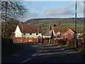
1

Woolbrook Park footpath
Local footpath No16 running behind post war bungalows.Few winter frosts require the use of the grit bin.
Image: © Anthony Vosper
Taken: 3 Sep 2009
0.06 miles
2

Mind your speed
Local footpath No.16 in Dark Lane, Bulverton.
please abide by the speed limit on this one.
Image: © Anthony Vosper
Taken: 2 Oct 2009
0.09 miles
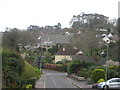
3
Houses on Bulverton Park
Looking along the B3176 to modern houses on the cul-de-sac north of Sidmouth. In the background rises Beacon Hill, in Image and Image
Image: © Derek Harper
Taken: 11 Jan 2012
0.09 miles
4

Former St Francis church rectory
Like many parish churches. The ministry to the community is now covered by a team looking after a number of congregations rather than just one.
The rectory is now a private dwelling.
Image: © Anthony Vosper
Taken: 4 Feb 2017
0.10 miles
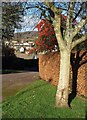
5

Bennetts Hill, Sidmouth
A fine show of berries on the grass verge where Woolbrook Park gives way to Bennetts Hill.
Image: © Derek Harper
Taken: 11 Jan 2012
0.10 miles
6
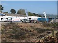
Fords self storage
A storage business on former railway land in Lower Woolbrook on the edge of Sidmouth.
Image: © Richard Webb
Taken: 19 Apr 2011
0.10 miles
7

Old Manor Cottage Bulverton
Situated in Dark lane, a wonderfully modernised former farm house.
Image: © Anthony Vosper
Taken: 3 Sep 2009
0.12 miles
8
A church in hiding
The church of St Francis nestles amongst the houses of Woolbrook.
Image: © Anthony Vosper
Taken: 31 Mar 2017
0.12 miles
9

All quiet on a day of destiny
St Francis church hall, Woolbrook.
Being used as a polling station on referendum day.
The car park may appear empty. The polling station however was busy throughout the day.
Image: © Anthony Vosper
Taken: 23 Jun 2016
0.12 miles
10
Colour on Bennetts Hill, Sidmouth
Red berries overhang a beech hedge. The map indicates that Sidmouth Footpath 16 ends here; its presence probably explains the wide verge which also finishes at this corner.
Image: © Derek Harper
Taken: 11 Jan 2012
0.12 miles